Sobradiel geodata
Sobradiel (Aragon) is a seat of a third-order administrative division; located in Spain in Europe/Madrid (GMT+2) time zone. With population of 754 people, there are 3297 cities with bigger population in this country. Compared to other cities in Spain, 67.1% of cities are located further ↓South; 76.9% of cities are located further ←West and 80.4% of cities have higher elevation than Sobradiel. Note1


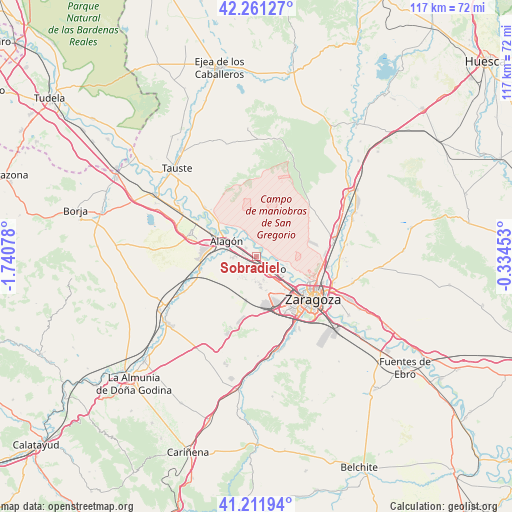
Sobradiel GPS coordinates[2]
41° 44' 19.5" North, 1° 2' 15.54" West
| Map corner | latitude | longitude |
|---|---|---|
| Upper-left | 42.26127°, | -1.74078° |
| Center: | 41.73875°, | -1.03765° |
| Lower-right: | 41.21194°, | -0.33453° |
| Map W x H: | 116.7×116.7 km | = 72.5×72.5mi |
| max Lat: | 43.74134° ⇑32.9% North |
| Sobradiel: | 41.73875° |
| min Lat: | ⇓67.1% South 27.64134° |
| min Long | Sobradiel | max Long |
| -18.00367° | -1.03765° | 4.2899° |
| W 76.9%⇐ | ⇒23.1% E |
Elevation
Elevation of Sobradiel is 213 m = 699 ft, and this is 385 m = 1263 ft below average elevation for this country.
| Max E: |
1682 m = 5518 ft | 80.4% |
| Avg. | 598 m = 1962 ft | |
| Sobradiel | 213 m = 699 ft | |
Min E: |
0 m = 0 ft | 19.6% |
See also: Spain elevation on elevation.city.
Geographical zone
Sobradiel is located in North temperate zone (between Tropic of Cancer and the Arctic Circle). Distance of this Northern Tropic circle is 2035 km =1264.5 mi to South.| Distance of | km | miles | from Sobradiel |
|---|---|---|---|
| North Pole | 5366.1 | 3334.3 | to North |
| Arctic Circle | 2760.3 | 1715.2 | to North |
| Tropic Cancer | 2035 | 1264.5 | to South |
| Equator | 4640.9 | 2883.7 | to South |


Nearby cities:
15 places around Sobradiel: (largest is in red/bold)
• Alagón
7.6 km =4.7 mi,  296°
296°
• Alcalá de Ebro
15.5 km =9.6 mi, 303°
• Almozara
14.2 km =8.8 mi,  127°
127°
• Bardallur
15.7 km =9.8 mi,  247°
247°
• Bárboles
12.7 km =7.9 mi, 254°
• Cabañas de Ebro
15.1 km =9.4 mi, 296°
• Delicias
14.7 km =9.1 mi, 132°
• Figueruelas
11.8 km =7.3 mi,  285°
285°
• Grisén
10.4 km =6.5 mi,  273°
273°
• Montecanal
14.7 km =9.1 mi,  145°
145°
• Oliver-Valdefierro
13.6 km =8.5 mi,  140°
140°
• Pinseque
5.2 km =3.2 mi, 267°
• Pleitas
14 km =8.7 mi,  257°
257°
• Torres de Berrellén
3.1 km =1.9 mi,  312°
312°
• Utebo
4.7 km =2.9 mi, 136°
Sources, notices
• [Note1] Compared only with cities in Spain existing in our database
• [Src1] Map data: © OpenStreetMap contributors (CC-BY-SA)
• [Src2] Other city data from geonames.org with taken over terms of usage.
• [Src3] Geographical zone / Annual Mean Temperature by Robert A. Rohde @ Wikipedia
