Grisén geodata
Grisén (Aragon) is a seat of a third-order administrative division; located in Spain in Europe/Madrid (GMT+2) time zone. With population of 475 people, there are 3947 cities with bigger population in this country. Compared to other cities in Spain, 67.2% of cities are located further ↓South; 75.9% of cities are located further ←West and 78.6% of cities have higher elevation than Grisén. Note1


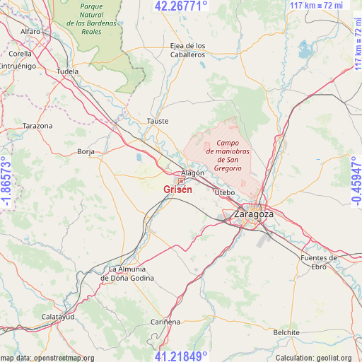
Grisén GPS coordinates[2]
41° 44' 42.864" North, 1° 9' 45.36" West
| Map corner | latitude | longitude |
|---|---|---|
| Upper-left | 42.26771°, | -1.86573° |
| Center: | 41.74524°, | -1.1626° |
| Lower-right: | 41.21849°, | -0.45947° |
| Map W x H: | 116.7×116.7 km | = 72.5×72.5mi |
| max Lat: | 43.74134° ⇑32.8% North |
| Grisén: | 41.74524° |
| min Lat: | ⇓67.2% South 27.64134° |
| min Long | Grisén | max Long |
| -18.00367° | -1.1626° | 4.2899° |
| W 75.9%⇐ | ⇒24.1% E |
Elevation
Elevation of Grisén is 246 m = 807 ft, and this is 352 m = 1155 ft below average elevation for this country.
| Max E: |
1682 m = 5518 ft | 78.6% |
| Avg. | 598 m = 1962 ft | |
| Grisén | 246 m = 807 ft | |
Min E: |
0 m = 0 ft | 21.4% |
See also: Spain elevation on elevation.city.
Geographical zone
Grisén is located in North temperate zone (between Tropic of Cancer and the Arctic Circle). Distance of this Northern Tropic circle is 2035.7 km =1264.9 mi to South.| Distance of | km | miles | from Grisén |
|---|---|---|---|
| North Pole | 5365.4 | 3333.9 | to North |
| Arctic Circle | 2759.5 | 1714.7 | to North |
| Tropic Cancer | 2035.7 | 1264.9 | to South |
| Equator | 4641.6 | 2884.2 | to South |


Nearby cities:
15 places around Grisén: (largest is in red/bold)
• Alagón
4.5 km =2.8 mi,  53°
53°
• Alcalá de Ebro
8.2 km =5.1 mi,  341°
341°
• Bardallur
7.9 km =4.9 mi,  211°
211°
• Bárboles
4.5 km =2.8 mi, 205°
• Cabañas de Ebro
6.8 km =4.2 mi,  333°
333°
• Figueruelas
2.6 km =1.6 mi, 336°
• Luceni
11.2 km =7 mi, 325°
• Pedrola
6.6 km =4.1 mi,  320°
320°
• Pinseque
5.2 km =3.2 mi,  100°
100°
• Plasencia de Jalón
9 km =5.6 mi,  218°
218°
• Pleitas
5 km =3.1 mi, 221°
• Remolinos
10.6 km =6.6 mi,  353°
353°
• Sobradiel
10.4 km =6.5 mi,  93°
93°
• Torres de Berrellén
8.2 km =5.1 mi,  80°
80°
• Urrea de Jalón
10.5 km =6.5 mi, 214°
Sources, notices
• [Note1] Compared only with cities in Spain existing in our database
• [Src1] Map data: © OpenStreetMap contributors (CC-BY-SA)
• [Src2] Other city data from geonames.org with taken over terms of usage.
• [Src3] Geographical zone / Annual Mean Temperature by Robert A. Rohde @ Wikipedia
