Palaciosrubios geodata
Palaciosrubios (Castille and León) is a seat of a third-order administrative division; located in Spain in Europe/Madrid (GMT+2) time zone. With population of 491 people, there are 3912 cities with bigger population in this country. Compared to other cities in Spain, 50.3% of cities are located further ↑North; 75% of cities are located further →East and 69.3% of cities have lower elevation than Palaciosrubios. Note1
Administrative division(s):
- Level 1: Castille and León
- Level 2: Provincia de Salamanca
- Level 3: Palaciosrubios


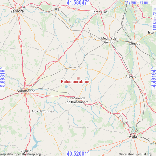
Palaciosrubios GPS coordinates[2]
41° 3' 8.568" North, 5° 11' 42.252" West
| Map corner | latitude | longitude |
|---|---|---|
| Upper-left | 41.58047°, | -5.89819° |
| Center: | 41.05238°, | -5.19507° |
| Lower-right: | 40.52001°, | -4.49194° |
| Map W x H: | 117.9×117.9 km | = 73.3×73.3mi |
| max Lat: | 43.74134° ⇑50.3% North |
| Palaciosrubios: | 41.05238° |
| min Lat: | ⇓49.7% South 27.64134° |
| min Long | Palaciosrubios | max Long |
| -18.00367° | -5.19507° | 4.2899° |
| W 25%⇐ | ⇒75% E |
Elevation
Elevation of Palaciosrubios is 808 m = 2651 ft, and this is 210 m = 689 ft above average elevation for this country.
| Max E: |
1682 m = 5518 ft | 30.7% |
| Palaciosrubios | 808 m 2651 ft | |
| Avg. | 598 m = 1962 ft | |
Min E: |
0 m = 0 ft | 69.3% |
See also: Spain elevation on elevation.city.
Geographical zone
Palaciosrubios is located in North temperate zone (between Tropic of Cancer and the Arctic Circle). Distance of this Northern Tropic circle is 1958.7 km =1217.1 mi to South.| Distance of | km | miles | from Palaciosrubios |
|---|---|---|---|
| North Pole | 5442.5 | 3381.8 | to North |
| Arctic Circle | 2836.6 | 1762.6 | to North |
| Tropic Cancer | 1958.7 | 1217.1 | to South |
| Equator | 4564.6 | 2836.3 | to South |


Nearby cities:
15 places around Palaciosrubios: (largest is in red/bold)
• Aldeaseca de la Frontera
12.4 km =7.7 mi,  184°
184°
• Cantalapiedra
8.3 km =5.2 mi,  6°
6°
• Cantalpino
11.4 km =7.1 mi,  270°
270°
• Horcajo de las Torres
8.8 km =5.5 mi,  80°
80°
• Mamblas
16.1 km =10 mi,  103°
103°
• Paradinas de San Juan
8.4 km =5.2 mi,  155°
155°
• Poveda de las Cintas
5.5 km =3.4 mi,  262°
262°
• Rasueros
10.7 km =6.6 mi,  107°
107°
• Rágama
8.3 km =5.2 mi,  136°
136°
• Tarazona de Guareña
14.1 km =8.8 mi,  340°
340°
• Vallesa de la Guareña
14.3 km =8.9 mi,  310°
310°
• Villaflores
4.8 km =3 mi,  316°
316°
• Villar de Gallimazo
13.5 km =8.4 mi,  215°
215°
• Villoría
16.3 km =10.1 mi,  246°
246°
• Zorita de la Frontera
4.2 km =2.6 mi, 181°
Sources, notices
• [Note1] Compared only with cities in Spain existing in our database
• [Src1] Map data: © OpenStreetMap contributors (CC-BY-SA)
• [Src2] Other city data from geonames.org with taken over terms of usage.
• [Src3] Geographical zone / Annual Mean Temperature by Robert A. Rohde @ Wikipedia
