Horcajo de las Torres geodata
Horcajo de las Torres (Castille and León) is a seat of a third-order administrative division; located in Spain in Europe/Madrid (GMT+2) time zone. With population of 709 people, there are 3390 cities with bigger population in this country. Compared to other cities in Spain, 50.1% of cities are located further ↓South; 73.6% of cities are located further →East and 70.8% of cities have lower elevation than Horcajo de las Torres. Note1
Administrative division(s):
- Level 1: Castille and León
- Level 2: Provincia de Ávila
- Level 3: Horcajo de las Torres
Current local time in Horcajo de las Torres:
10:43 PM, ThursdayDifference from your time zone: hours


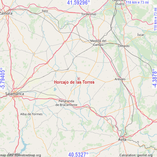
Horcajo de las Torres GPS coordinates[2]
41° 3' 53.892" North, 5° 5' 27.312" West
| Map corner | latitude | longitude |
|---|---|---|
| Upper-left | 41.59296°, | -5.79405° |
| Center: | 41.06497°, | -5.09092° |
| Lower-right: | 40.5327°, | -4.3878° |
| Map W x H: | 117.9×117.9 km | = 73.3×73.3mi |
| max Lat: | 43.74134° ⇑49.9% North |
| Horcajo de las Torres: | 41.06497° |
| min Lat: | ⇓50.1% South 27.64134° |
| min Long | Horcajo de las | max Long |
| -18.00367° | -5.09092° | 4.2899° |
| W 26.4%⇐ | ⇒73.6% E |
Elevation
Elevation of Horcajo de las Torres is 819 m = 2687 ft, and this is 221 m = 725 ft above average elevation for this country.
| Max E: |
1682 m = 5518 ft | 29.2% |
| Horcajo de las Torres | 819 m 2687 ft | |
| Avg. | 598 m = 1962 ft | |
Min E: |
0 m = 0 ft | 70.8% |
See also: Spain elevation on elevation.city.
Geographical zone
Horcajo de las Torres is located in North temperate zone (between Tropic of Cancer and the Arctic Circle). Distance of this Northern Tropic circle is 1960.1 km =1217.9 mi to South.| Distance of | km | miles | from Horcajo de las Torres |
|---|---|---|---|
| North Pole | 5441.1 | 3380.9 | to North |
| Arctic Circle | 2835.2 | 1761.7 | to North |
| Tropic Cancer | 1960.1 | 1217.9 | to South |
| Equator | 4566 | 2837.2 | to South |


Nearby cities:
15 places around Horcajo de las Torres: (largest is in red/bold)
• Barromán
13.4 km =8.3 mi,  89°
89°
• Bercial de Zapardiel
10.4 km =6.5 mi,  101°
101°
• Cabezas del Pozo
13.4 km =8.3 mi,  121°
121°
• Cantalapiedra
10.3 km =6.4 mi,  311°
311°
• Cisla
12.7 km =7.9 mi,  149°
149°
• Madrigal de las Altas Torres
8.2 km =5.1 mi,  70°
70°
• Mamblas
8.6 km =5.3 mi,  126°
126°
• Moraleja de Matacabras
12.2 km =7.6 mi, 67°
• Palaciosrubios
8.8 km =5.5 mi,  260°
260°
• Paradinas de San Juan
10.5 km =6.5 mi,  210°
210°
• Poveda de las Cintas
14.3 km =8.9 mi, 261°
• Rasueros
4.8 km =3 mi,  162°
162°
• Rágama
8.1 km =5 mi,  202°
202°
• Villaflores
12.2 km =7.6 mi,  279°
279°
• Zorita de la Frontera
10.5 km =6.5 mi,  237°
237°
Sources, notices
• [Note1] Compared only with cities in Spain existing in our database
• [Src1] Map data: © OpenStreetMap contributors (CC-BY-SA)
• [Src2] Other city data from geonames.org with taken over terms of usage.
• [Src3] Geographical zone / Annual Mean Temperature by Robert A. Rohde @ Wikipedia
