Padrenda geodata
Padrenda (Galicia) is a seat of a third-order administrative division; located in Spain in Europe/Madrid (GMT+2) time zone. With population of 2,433 people, there are 1925 cities with bigger population in this country. Compared to other cities in Spain, 77.4% of cities are located further ↓South; 96.7% of cities are located further →East and 76.9% of cities have higher elevation than Padrenda. Note1


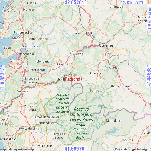
Padrenda GPS coordinates[2]
42° 7' 59.988" North, 8° 9' 0" West
| Map corner | latitude | longitude |
|---|---|---|
| Upper-left | 42.65261°, | -8.85313° |
| Center: | 42.13333°, | -8.15° |
| Lower-right: | 41.60976°, | -7.44688° |
| Map W x H: | 116×116 km | = 72.1×72.1mi |
| max Lat: | 43.74134° ⇑22.6% North |
| Padrenda: | 42.13333° |
| min Lat: | ⇓77.4% South 27.64134° |
| min Long | Padrenda | max Long |
| -18.00367° | -8.15° | 4.2899° |
| W 3.3%⇐ | ⇒96.7% E |
Elevation
Elevation of Padrenda is 273 m = 896 ft, and this is 325 m = 1066 ft below average elevation for this country.
| Max E: |
1682 m = 5518 ft | 76.9% |
| Avg. | 598 m = 1962 ft | |
| Padrenda | 273 m = 896 ft | |
Min E: |
0 m = 0 ft | 23.1% |
See also: Spain elevation on elevation.city.
Geographical zone
Padrenda is located in North temperate zone (between Tropic of Cancer and the Arctic Circle). Distance of this Northern Tropic circle is 2078.9 km =1291.8 mi to South.| Distance of | km | miles | from Padrenda |
|---|---|---|---|
| North Pole | 5322.3 | 3307.1 | to North |
| Arctic Circle | 2716.4 | 1687.9 | to North |
| Tropic Cancer | 2078.9 | 1291.8 | to South |
| Equator | 4684.8 | 2911 | to South |


Nearby cities:
15 places around Padrenda: (largest is in red/bold)
• Arbo
13.9 km =8.6 mi,  262°
262°
• Bande
18.4 km =11.4 mi,  128°
128°
• Beade
22 km =13.7 mi,  4°
4°
• Carballeda de Avia
20.9 km =13 mi,  356°
356°
• Cartelle
14.6 km =9.1 mi,  26°
26°
• Castrelo de Miño
19.5 km =12.1 mi,  20°
20°
• Celanova
16.2 km =10.1 mi,  82°
82°
• Cenlle
23.7 km =14.7 mi,  12°
12°
• Cortegada
8.6 km =5.3 mi,  350°
350°
• Covelo
19.9 km =12.4 mi,  304°
304°
• Entrimo
22.4 km =13.9 mi,  173°
173°
• Melón
15.1 km =9.4 mi,  339°
339°
• Quintela de Leirado
4.1 km =2.5 mi, 80°
• Ribadavia
17.2 km =10.7 mi, 1°
• Verea
12.7 km =7.9 mi,  103°
103°
Sources, notices
• [Note1] Compared only with cities in Spain existing in our database
• [Src1] Map data: © OpenStreetMap contributors (CC-BY-SA)
• [Src2] Other city data from geonames.org with taken over terms of usage.
• [Src3] Geographical zone / Annual Mean Temperature by Robert A. Rohde @ Wikipedia
