Cartelle geodata
Cartelle (Galicia) is a seat of a third-order administrative division; located in Spain in Europe/Madrid (GMT+2) time zone. With population of 3,496 people, there are 1589 cities with bigger population in this country. Compared to other cities in Spain, 80.6% of cities are located further ↓South; 96.5% of cities are located further →East and 71.3% of cities have higher elevation than Cartelle. Note1


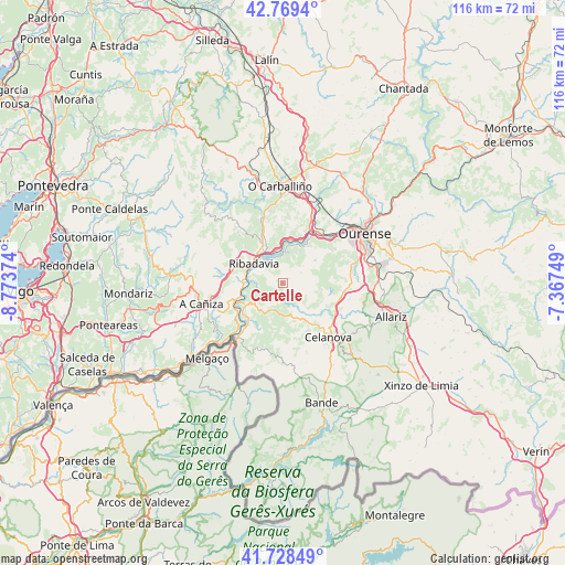
Cartelle GPS coordinates[2]
42° 15' 3.924" North, 8° 4' 14.232" West
| Map corner | latitude | longitude |
|---|---|---|
| Upper-left | 42.7694°, | -8.77374° |
| Center: | 42.25109°, | -8.07062° |
| Lower-right: | 41.72849°, | -7.36749° |
| Map W x H: | 115.7×115.7 km | = 71.9×71.9mi |
| max Lat: | 43.74134° ⇑19.4% North |
| Cartelle: | 42.25109° |
| min Lat: | ⇓80.6% South 27.64134° |
| min Long | Cartelle | max Long |
| -18.00367° | -8.07062° | 4.2899° |
| W 3.5%⇐ | ⇒96.5% E |
Elevation
Elevation of Cartelle is 362 m = 1188 ft, and this is 236 m = 774 ft below average elevation for this country.
| Max E: |
1682 m = 5518 ft | 71.3% |
| Avg. | 598 m = 1962 ft | |
| Cartelle | 362 m = 1188 ft | |
Min E: |
0 m = 0 ft | 28.7% |
See also: Spain elevation on elevation.city.
Geographical zone
Cartelle is located in North temperate zone (between Tropic of Cancer and the Arctic Circle). Distance of this Northern Tropic circle is 2092 km =1299.9 mi to South.| Distance of | km | miles | from Cartelle |
|---|---|---|---|
| North Pole | 5309.2 | 3299 | to North |
| Arctic Circle | 2703.3 | 1679.8 | to North |
| Tropic Cancer | 2092 | 1299.9 | to South |
| Equator | 4697.9 | 2919.1 | to South |


Nearby cities:
15 places around Cartelle: (largest is in red/bold)
• Beade
10.1 km =6.3 mi,  331°
331°
• Carballeda de Avia
11 km =6.8 mi,  315°
315°
• Castrelo de Miño
5.2 km =3.2 mi,  3°
3°
• Celanova
14.5 km =9 mi,  138°
138°
• Cenlle
10.2 km =6.3 mi,  351°
351°
• Cortegada
9.3 km =5.8 mi,  240°
240°
• Maside
18.1 km =11.2 mi,  11°
11°
• Melón
11.8 km =7.3 mi,  274°
274°
• Padrenda
14.6 km =9.1 mi,  206°
206°
• Punxín
14.2 km =8.8 mi,  20°
20°
• Quintela de Leirado
12.6 km =7.8 mi,  191°
191°
• Ribadavia
7.3 km =4.5 mi,  304°
304°
• San Amaro
13.7 km =8.5 mi,  359°
359°
• Toén
12.1 km =7.5 mi,  52°
52°
• Verea
17.1 km =10.6 mi,  160°
160°
Sources, notices
• [Note1] Compared only with cities in Spain existing in our database
• [Src1] Map data: © OpenStreetMap contributors (CC-BY-SA)
• [Src2] Other city data from geonames.org with taken over terms of usage.
• [Src3] Geographical zone / Annual Mean Temperature by Robert A. Rohde @ Wikipedia
