Cenlle geodata
Cenlle (Galicia) is a seat of a third-order administrative division; located in Spain in Europe/Madrid (GMT+2) time zone. With population of 1,555 people, there are 2420 cities with bigger population in this country. Compared to other cities in Spain, 83.1% of cities are located further ↓South; 96.5% of cities are located further →East and 68.5% of cities have higher elevation than Cenlle. Note1


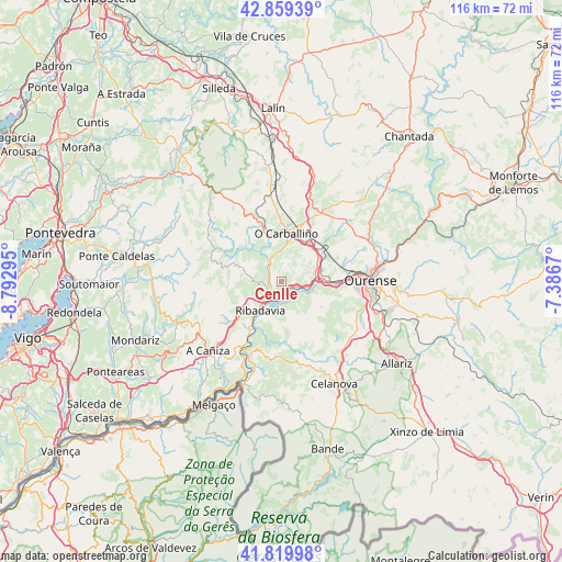
Cenlle GPS coordinates[2]
42° 20' 30.588" North, 8° 5' 23.352" West
| Map corner | latitude | longitude |
|---|---|---|
| Upper-left | 42.85939°, | -8.79295° |
| Center: | 42.34183°, | -8.08982° |
| Lower-right: | 41.81998°, | -7.3867° |
| Map W x H: | 115.6×115.6 km | = 71.8×71.8mi |
| max Lat: | 43.74134° ⇑16.9% North |
| Cenlle: | 42.34183° |
| min Lat: | ⇓83.1% South 27.64134° |
| min Long | Cenlle | max Long |
| -18.00367° | -8.08982° | 4.2899° |
| W 3.5%⇐ | ⇒96.5% E |
Elevation
Elevation of Cenlle is 408 m = 1339 ft, and this is 190 m = 623 ft below average elevation for this country.
| Max E: |
1682 m = 5518 ft | 68.5% |
| Avg. | 598 m = 1962 ft | |
| Cenlle | 408 m = 1339 ft | |
Min E: |
0 m = 0 ft | 31.5% |
See also: Spain elevation on elevation.city.
Geographical zone
Cenlle is located in North temperate zone (between Tropic of Cancer and the Arctic Circle). Distance of this Northern Tropic circle is 2102.1 km =1306.2 mi to South.| Distance of | km | miles | from Cenlle |
|---|---|---|---|
| North Pole | 5299.1 | 3292.7 | to North |
| Arctic Circle | 2693.2 | 1673.5 | to North |
| Tropic Cancer | 2102.1 | 1306.2 | to South |
| Equator | 4708 | 2925.4 | to South |


Nearby cities:
15 places around Cenlle: (largest is in red/bold)
• Amoeiro
14.2 km =8.8 mi,  54°
54°
• Avión
13.9 km =8.6 mi,  289°
289°
• Beade
3.5 km =2.2 mi,  249°
249°
• Boborás
11.1 km =6.9 mi,  336°
336°
• Carballeda de Avia
6.5 km =4 mi, 249°
• Cartelle
10.2 km =6.3 mi,  171°
171°
• Castrelo de Miño
5.2 km =3.2 mi,  158°
158°
• Cortegada
16 km =9.9 mi,  203°
203°
• Maside
9.3 km =5.8 mi,  34°
34°
• Melón
13.7 km =8.5 mi,  228°
228°
• O Carballiño
10 km =6.2 mi,  5°
5°
• Punxín
7.3 km =4.5 mi,  63°
63°
• Ribadavia
7.4 km =4.6 mi,  216°
216°
• San Amaro
3.8 km =2.4 mi,  20°
20°
• Toén
11.5 km =7.1 mi,  103°
103°
Sources, notices
• [Note1] Compared only with cities in Spain existing in our database
• [Src1] Map data: © OpenStreetMap contributors (CC-BY-SA)
• [Src2] Other city data from geonames.org with taken over terms of usage.
• [Src3] Geographical zone / Annual Mean Temperature by Robert A. Rohde @ Wikipedia
