Orera geodata
Orera (Aragon) is a seat of a third-order administrative division; located in Spain in Europe/Madrid (GMT+2) time zone. With population of 132 people, there are 5562 cities with bigger population in this country. Compared to other cities in Spain, 55.3% of cities are located further ↓South; 73.2% of cities are located further ←West and 61.5% of cities have lower elevation than Orera. Note1


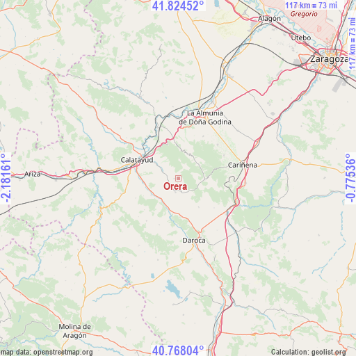
Orera GPS coordinates[2]
41° 17' 54.312" North, 1° 28' 42.564" West
| Map corner | latitude | longitude |
|---|---|---|
| Upper-left | 41.82452°, | -2.18161° |
| Center: | 41.29842°, | -1.47849° |
| Lower-right: | 40.76804°, | -0.77536° |
| Map W x H: | 117.5×117.5 km | = 73×73mi |
| max Lat: | 43.74134° ⇑44.7% North |
| Orera: | 41.29842° |
| min Lat: | ⇓55.3% South 27.64134° |
| min Long | Orera | max Long |
| -18.00367° | -1.47849° | 4.2899° |
| W 73.2%⇐ | ⇒26.8% E |
Elevation
Elevation of Orera is 754 m = 2474 ft, and this is 156 m = 512 ft above average elevation for this country.
| Max E: |
1682 m = 5518 ft | 38.5% |
| Orera | 754 m 2474 ft | |
| Avg. | 598 m = 1962 ft | |
Min E: |
0 m = 0 ft | 61.5% |
See also: Spain elevation on elevation.city.
Geographical zone
Orera is located in North temperate zone (between Tropic of Cancer and the Arctic Circle). Distance of this Northern Tropic circle is 1986 km =1234 mi to South.| Distance of | km | miles | from Orera |
|---|---|---|---|
| North Pole | 5415.1 | 3364.8 | to North |
| Arctic Circle | 2809.2 | 1745.6 | to North |
| Tropic Cancer | 1986 | 1234 | to South |
| Equator | 4592 | 2853.3 | to South |


Nearby cities:
15 places around Orera: (largest is in red/bold)
• Codos
8.7 km =5.4 mi,  94°
94°
• El Frasno
12.9 km =8 mi,  353°
353°
• Fuentes de Jiloca
9.1 km =5.7 mi,  211°
211°
• Langa del Castillo
11.7 km =7.3 mi,  145°
145°
• Maluenda
11.6 km =7.2 mi,  264°
264°
• Mara
3.5 km =2.2 mi,  253°
253°
• Montón
10.7 km =6.6 mi,  196°
196°
• Morata de Jiloca
10.6 km =6.6 mi,  238°
238°
• Ruesca
1.7 km =1.1 mi,  188°
188°
• Santa Cruz de Grío
9 km =5.6 mi,  26°
26°
• Sediles
6.9 km =4.3 mi,  320°
320°
• Tobed
8 km =5 mi,  55°
55°
• Velilla de Jiloca
10.8 km =6.7 mi, 256°
• Villafeliche
11.8 km =7.3 mi, 192°
• Villalba de Perejil
6.7 km =4.2 mi,  298°
298°
Sources, notices
• [Note1] Compared only with cities in Spain existing in our database
• [Src1] Map data: © OpenStreetMap contributors (CC-BY-SA)
• [Src2] Other city data from geonames.org with taken over terms of usage.
• [Src3] Geographical zone / Annual Mean Temperature by Robert A. Rohde @ Wikipedia
