Mara geodata
Mara (Aragon) is a seat of a third-order administrative division; located in Spain in Europe/Madrid (GMT+2) time zone. With population of 194 people, there are 5078 cities with bigger population in this country. Compared to other cities in Spain, 55.2% of cities are located further ↓South; 72.7% of cities are located further ←West and 53.7% of cities have lower elevation than Mara. Note1


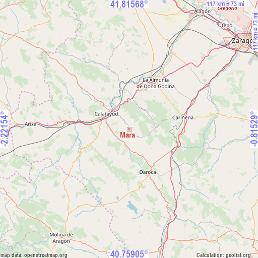
Mara GPS coordinates[2]
41° 17' 22.2" North, 1° 31' 6.312" West
| Map corner | latitude | longitude |
|---|---|---|
| Upper-left | 41.81568°, | -2.22154° |
| Center: | 41.2895°, | -1.51842° |
| Lower-right: | 40.75905°, | -0.81529° |
| Map W x H: | 117.5×117.5 km | = 73×73mi |
| max Lat: | 43.74134° ⇑44.8% North |
| Mara: | 41.2895° |
| min Lat: | ⇓55.2% South 27.64134° |
| min Long | Mara | max Long |
| -18.00367° | -1.51842° | 4.2899° |
| W 72.7%⇐ | ⇒27.3% E |
Elevation
Elevation of Mara is 697 m = 2287 ft, and this is 99 m = 325 ft above average elevation for this country.
| Max E: |
1682 m = 5518 ft | 46.3% |
| Mara | 697 m 2287 ft | |
| Avg. | 598 m = 1962 ft | |
Min E: |
0 m = 0 ft | 53.7% |
See also: Spain elevation on elevation.city.
Geographical zone
Mara is located in North temperate zone (between Tropic of Cancer and the Arctic Circle). Distance of this Northern Tropic circle is 1985 km =1233.4 mi to South.| Distance of | km | miles | from Mara |
|---|---|---|---|
| North Pole | 5416.1 | 3365.4 | to North |
| Arctic Circle | 2810.2 | 1746.2 | to North |
| Tropic Cancer | 1985 | 1233.4 | to South |
| Equator | 4591 | 2852.7 | to South |


Nearby cities:
15 places around Mara: (largest is in red/bold)
• Codos
12 km =7.5 mi,  88°
88°
• Fuentes de Jiloca
6.9 km =4.3 mi,  192°
192°
• Maluenda
8.2 km =5.1 mi,  268°
268°
• Montón
9.2 km =5.7 mi,  178°
178°
• Morata de Jiloca
7.3 km =4.5 mi,  230°
230°
• Olvés
12.1 km =7.5 mi,  242°
242°
• Orera
3.5 km =2.2 mi,  73°
73°
• Paracuellos de Jiloca
10.5 km =6.5 mi,  284°
284°
• Ruesca
3.2 km =2 mi,  102°
102°
• Santa Cruz de Grío
11.6 km =7.2 mi,  39°
39°
• Sediles
6.4 km =4 mi,  349°
349°
• Tobed
11.3 km =7 mi,  61°
61°
• Velilla de Jiloca
7.3 km =4.5 mi,  257°
257°
• Villafeliche
10.5 km =6.5 mi, 176°
• Villalba de Perejil
4.9 km =3 mi,  329°
329°
Sources, notices
• [Note1] Compared only with cities in Spain existing in our database
• [Src1] Map data: © OpenStreetMap contributors (CC-BY-SA)
• [Src2] Other city data from geonames.org with taken over terms of usage.
• [Src3] Geographical zone / Annual Mean Temperature by Robert A. Rohde @ Wikipedia
