Codos geodata
Codos (Aragon) is a seat of a third-order administrative division; located in Spain in Europe/Madrid (GMT+2) time zone. With population of 273 people, there are 4613 cities with bigger population in this country. Compared to other cities in Spain, 55.2% of cities are located further ↓South; 74.1% of cities are located further ←West and 61% of cities have lower elevation than Codos. Note1


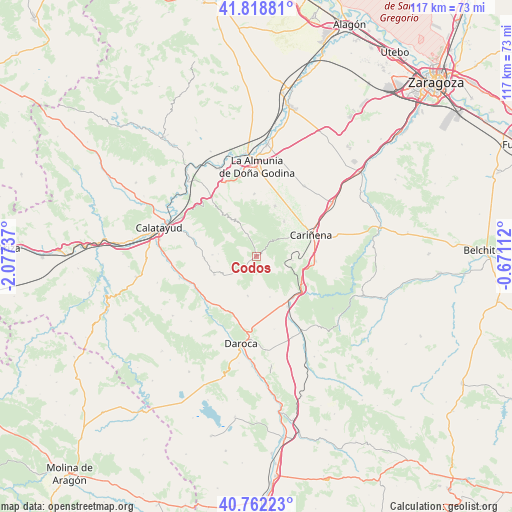
Codos GPS coordinates[2]
41° 17' 33.576" North, 1° 22' 27.3" West
| Map corner | latitude | longitude |
|---|---|---|
| Upper-left | 41.81881°, | -2.07737° |
| Center: | 41.29266°, | -1.37425° |
| Lower-right: | 40.76223°, | -0.67112° |
| Map W x H: | 117.5×117.5 km | = 73×73mi |
| max Lat: | 43.74134° ⇑44.8% North |
| Codos: | 41.29266° |
| min Lat: | ⇓55.2% South 27.64134° |
| min Long | Codos | max Long |
| -18.00367° | -1.37425° | 4.2899° |
| W 74.1%⇐ | ⇒25.9% E |
Elevation
Elevation of Codos is 751 m = 2464 ft, and this is 153 m = 502 ft above average elevation for this country.
| Max E: |
1682 m = 5518 ft | 39% |
| Codos | 751 m 2464 ft | |
| Avg. | 598 m = 1962 ft | |
Min E: |
0 m = 0 ft | 61% |
See also: Spain elevation on elevation.city.
Geographical zone
Codos is located in North temperate zone (between Tropic of Cancer and the Arctic Circle). Distance of this Northern Tropic circle is 1985.4 km =1233.7 mi to South.| Distance of | km | miles | from Codos |
|---|---|---|---|
| North Pole | 5415.7 | 3365.2 | to North |
| Arctic Circle | 2809.9 | 1746 | to North |
| Tropic Cancer | 1985.4 | 1233.7 | to South |
| Equator | 4591.3 | 2852.9 | to South |


Nearby cities:
15 places around Codos: (largest is in red/bold)
• Aguarón
10.1 km =6.3 mi,  59°
59°
• Almonacid de la Sierra
12.4 km =7.7 mi,  19°
19°
• Cariñena
13.5 km =8.4 mi,  68°
68°
• Cosuenda
10.3 km =6.4 mi,  37°
37°
• Encinacorba
8.3 km =5.2 mi,  95°
95°
• Langa del Castillo
9.2 km =5.7 mi,  192°
192°
• Mainar
12.6 km =7.8 mi,  151°
151°
• Mara
12 km =7.5 mi,  268°
268°
• Orera
8.7 km =5.4 mi, 274°
• Paniza
13.6 km =8.5 mi,  94°
94°
• Ruesca
9 km =5.6 mi,  263°
263°
• Santa Cruz de Grío
9.8 km =6.1 mi,  331°
331°
• Tobed
5.5 km =3.4 mi,  337°
337°
• Torralbilla
9.7 km =6 mi,  161°
161°
• Villarreal de Huerva
13.4 km =8.3 mi, 148°
Sources, notices
• [Note1] Compared only with cities in Spain existing in our database
• [Src1] Map data: © OpenStreetMap contributors (CC-BY-SA)
• [Src2] Other city data from geonames.org with taken over terms of usage.
• [Src3] Geographical zone / Annual Mean Temperature by Robert A. Rohde @ Wikipedia
