Fuentes de Jiloca geodata
Fuentes de Jiloca (Aragon) is a seat of a third-order administrative division; located in Spain in Europe/Madrid (GMT+2) time zone. With population of 300 people, there are 4499 cities with bigger population in this country. Compared to other cities in Spain, 53.9% of cities are located further ↓South; 72.5% of cities are located further ←West and 53.2% of cities have lower elevation than Fuentes de Jiloca. Note1
Administrative division(s):
- Level 1: Aragon
- Level 2: Provincia de Zaragoza
- Level 3: Fuentes de Jiloca


Fuentes de Jiloca GPS coordinates[2]
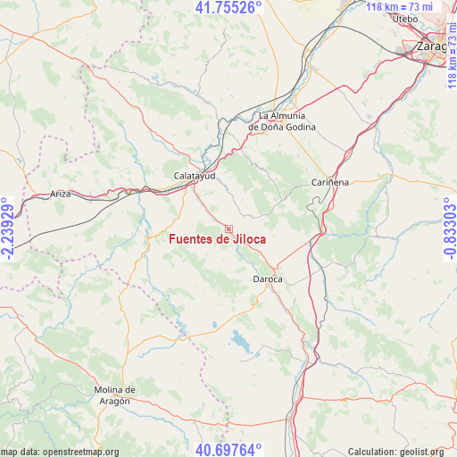
41° 13' 42.924" North, 1° 32' 10.176" West
| Map corner | latitude | longitude |
|---|---|---|
| Upper-left | 41.75526°, | -2.23929° |
| Center: | 41.22859°, | -1.53616° |
| Lower-right: | 40.69764°, | -0.83303° |
| Map W x H: | 117.6×117.6 km | = 73.1×73.1mi |
| max Lat: | 43.74134° ⇑46.1% North |
| Fuentes de Jiloca: | 41.22859° |
| min Lat: | ⇓53.9% South 27.64134° |
| min Long | Fuentes de Jilo | max Long |
| -18.00367° | -1.53616° | 4.2899° |
| W 72.5%⇐ | ⇒27.5% E |
Elevation
Elevation of Fuentes de Jiloca is 693 m = 2274 ft, and this is 95 m = 312 ft above average elevation for this country.
| Max E: |
1682 m = 5518 ft | 46.8% |
| Fuentes de Jiloca | 693 m 2274 ft | |
| Avg. | 598 m = 1962 ft | |
Min E: |
0 m = 0 ft | 53.2% |
See also: Spain elevation on elevation.city.
Geographical zone
Fuentes de Jiloca is located in North temperate zone (between Tropic of Cancer and the Arctic Circle). Distance of this Northern Tropic circle is 1978.3 km =1229.3 mi to South.| Distance of | km | miles | from Fuentes de Jiloca |
|---|---|---|---|
| North Pole | 5422.9 | 3369.6 | to North |
| Arctic Circle | 2817 | 1750.4 | to North |
| Tropic Cancer | 1978.3 | 1229.3 | to South |
| Equator | 4584.2 | 2848.5 | to South |


Nearby cities:
15 places around Fuentes de Jiloca: (largest is in red/bold)
• Acered
8.6 km =5.3 mi,  221°
221°
• Alarba
7 km =4.3 mi,  247°
247°
• Atea
7.7 km =4.8 mi,  191°
191°
• Castejón de Alarba
9.7 km =6 mi,  239°
239°
• Maluenda
9.4 km =5.8 mi,  314°
314°
• Manchones
10.5 km =6.5 mi,  146°
146°
• Mara
6.9 km =4.3 mi,  12°
12°
• Montón
3 km =1.9 mi,  144°
144°
• Morata de Jiloca
4.7 km =2.9 mi,  297°
297°
• Murero
8.9 km =5.5 mi, 149°
• Olvés
9.3 km =5.8 mi,  277°
277°
• Orera
9.1 km =5.7 mi,  31°
31°
• Ruesca
7.6 km =4.7 mi,  36°
36°
• Velilla de Jiloca
7.7 km =4.8 mi, 312°
• Villafeliche
4.3 km =2.7 mi, 149°
Sources, notices
• [Note1] Compared only with cities in Spain existing in our database
• [Src1] Map data: © OpenStreetMap contributors (CC-BY-SA)
• [Src2] Other city data from geonames.org with taken over terms of usage.
• [Src3] Geographical zone / Annual Mean Temperature by Robert A. Rohde @ Wikipedia
