Sagàs geodata
Sagàs (Catalonia) is a seat of a third-order administrative division; located in Spain in Europe/Madrid (GMT+2) time zone. With population of 135 people, there are 5545 cities with bigger population in this country. Compared to other cities in Spain, 75.1% of cities are located further ↓South; 93.3% of cities are located further ←West and 57.6% of cities have lower elevation than Sagàs. Note1


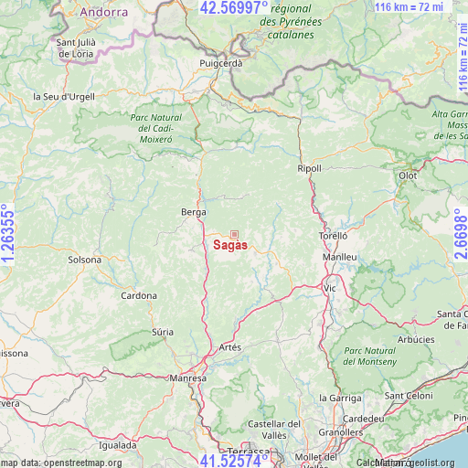
Sagàs GPS coordinates[2]
42° 3' 0" North, 1° 58' 0.012" East
| Map corner | latitude | longitude |
|---|---|---|
| Upper-left | 42.56997°, | 1.26355° |
| Center: | 42.05°, | 1.96667° |
| Lower-right: | 41.52574°, | 2.6698° |
| Map W x H: | 116.1×116.1 km | = 72.1×72.1mi |
| max Lat: | 43.74134° ⇑24.9% North |
| Sagàs: | 42.05° |
| min Lat: | ⇓75.1% South 27.64134° |
| min Long | Sagàs | max Long |
| -18.00367° | 1.96667° | 4.2899° |
| W 93.3%⇐ | ⇒6.7% E |
Elevation
Elevation of Sagàs is 727 m = 2385 ft, and this is 129 m = 423 ft above average elevation for this country.
| Max E: |
1682 m = 5518 ft | 42.4% |
| Sagàs | 727 m 2385 ft | |
| Avg. | 598 m = 1962 ft | |
Min E: |
0 m = 0 ft | 57.6% |
See also: Spain elevation on elevation.city.
Geographical zone
Sagàs is located in North temperate zone (between Tropic of Cancer and the Arctic Circle). Distance of this Northern Tropic circle is 2069.6 km =1286 mi to South.| Distance of | km | miles | from Sagàs |
|---|---|---|---|
| North Pole | 5331.5 | 3312.8 | to North |
| Arctic Circle | 2725.7 | 1693.7 | to North |
| Tropic Cancer | 2069.6 | 1286 | to South |
| Equator | 4675.5 | 2905.2 | to South |


Nearby cities:
15 places around Sagàs: (largest is in red/bold)
• Alpens
13.5 km =8.4 mi,  55°
55°
• Avià
9.8 km =6.1 mi,  280°
280°
• Berga
11.6 km =7.2 mi,  301°
301°
• Borredà
9.8 km =6.1 mi,  13°
13°
• Gironella
7.4 km =4.6 mi,  256°
256°
• Olost
12.8 km =8 mi,  124°
124°
• Olvan
5.8 km =3.6 mi,  288°
288°
• Oristà
15.4 km =9.6 mi,  147°
147°
• Prats de Lluçanès
6.6 km =4.1 mi, 123°
• Puig-reig
11.5 km =7.1 mi,  216°
216°
• Sant Boi de Lluçanès
15.1 km =9.4 mi,  90°
90°
• Sant Feliu Sasserra
12.4 km =7.7 mi, 153°
• Sant Maurici de la Quar
3.7 km =2.3 mi,  0°
0°
• Vilada
10.1 km =6.3 mi,  343°
343°
• les Llosses
16.6 km =10.3 mi,  48°
48°
Sources, notices
• [Note1] Compared only with cities in Spain existing in our database
• [Src1] Map data: © OpenStreetMap contributors (CC-BY-SA)
• [Src2] Other city data from geonames.org with taken over terms of usage.
• [Src3] Geographical zone / Annual Mean Temperature by Robert A. Rohde @ Wikipedia
