Oliete geodata
Oliete (Aragon) is a seat of a third-order administrative division; located in Spain in Europe/Madrid (GMT+2) time zone. With population of 474 people, there are 3951 cities with bigger population in this country. Compared to other cities in Spain, 51.6% of cities are located further ↑North; 80.1% of cities are located further ←West and 57.5% of cities have higher elevation than Oliete. Note1


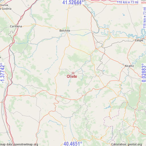
Oliete GPS coordinates[2]
40° 59' 52.476" North, 0° 40' 27.444" West
| Map corner | latitude | longitude |
|---|---|---|
| Upper-left | 41.52644°, | -1.37742° |
| Center: | 40.99791°, | -0.67429° |
| Lower-right: | 40.4651°, | 0.02883° |
| Map W x H: | 118×118 km | = 73.3×73.3mi |
| max Lat: | 43.74134° ⇑51.6% North |
| Oliete: | 40.99791° |
| min Lat: | ⇓48.4% South 27.64134° |
| min Long | Oliete | max Long |
| -18.00367° | -0.67429° | 4.2899° |
| W 80.1%⇐ | ⇒19.9% E |
Elevation
Elevation of Oliete is 557 m = 1827 ft, and this is 41 m = 135 ft below average elevation for this country.
| Max E: |
1682 m = 5518 ft | 57.5% |
| Avg. | 598 m = 1962 ft | |
| Oliete | 557 m = 1827 ft | |
Min E: |
0 m = 0 ft | 42.5% |
See also: Spain elevation on elevation.city.
Geographical zone
Oliete is located in North temperate zone (between Tropic of Cancer and the Arctic Circle). Distance of this Northern Tropic circle is 1952.6 km =1213.3 mi to South.| Distance of | km | miles | from Oliete |
|---|---|---|---|
| North Pole | 5448.5 | 3385.5 | to North |
| Arctic Circle | 2842.6 | 1766.3 | to North |
| Tropic Cancer | 1952.6 | 1213.3 | to South |
| Equator | 4558.5 | 2832.5 | to South |


Nearby cities:
15 places around Oliete: (largest is in red/bold)
• Alacón
3.7 km =2.3 mi,  327°
327°
• Alcaine
5.6 km =3.5 mi,  208°
208°
• Alloza
12.6 km =7.8 mi,  104°
104°
• Andorra
19.2 km =11.9 mi, 97°
• Ariño
7.8 km =4.8 mi,  62°
62°
• Blesa
18.7 km =11.6 mi,  288°
288°
• Cortes de Aragón
13.8 km =8.6 mi,  258°
258°
• Crivillén
15.2 km =9.4 mi,  147°
147°
• Estercuel
16.3 km =10.1 mi,  167°
167°
• Josa
9.1 km =5.7 mi,  238°
238°
• Maicas
18.5 km =11.5 mi, 259°
• Muniesa
12.2 km =7.6 mi, 288°
• Obón
11.2 km =7 mi,  201°
201°
• Plou
15.1 km =9.4 mi,  267°
267°
• Torre de las Arcas
17.8 km =11.1 mi,  191°
191°
Sources, notices
• [Note1] Compared only with cities in Spain existing in our database
• [Src1] Map data: © OpenStreetMap contributors (CC-BY-SA)
• [Src2] Other city data from geonames.org with taken over terms of usage.
• [Src3] Geographical zone / Annual Mean Temperature by Robert A. Rohde @ Wikipedia
