Navascués geodata
Navascués (Navarre) is a seat of a third-order administrative division; located in Spain in Europe/Madrid (GMT+2) time zone. With population of 198 people, there are 5045 cities with bigger population in this country. Compared to other cities in Spain, 91.7% of cities are located further ↓South; 76.2% of cities are located further ←West and 53.6% of cities have higher elevation than Navascués. Note1
Administrative division(s):
- Level 1: Navarre
- Level 2: Provincia de Navarra
- Level 3: Navascués/Nabaskoze


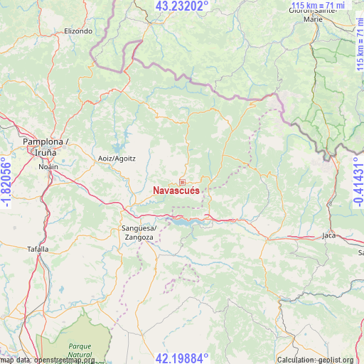
Navascués GPS coordinates[2]
42° 43' 3.288" North, 1° 7' 2.784" West
| Map corner | latitude | longitude |
|---|---|---|
| Upper-left | 43.23202°, | -1.82056° |
| Center: | 42.71758°, | -1.11744° |
| Lower-right: | 42.19884°, | -0.41431° |
| Map W x H: | 114.9×114.9 km | = 71.4×71.4mi |
| max Lat: | 43.74134° ⇑8.3% North |
| Navascués: | 42.71758° |
| min Lat: | ⇓91.7% South 27.64134° |
| min Long | Navascués | max Long |
| -18.00367° | -1.11744° | 4.2899° |
| W 76.2%⇐ | ⇒23.8% E |
Elevation
Elevation of Navascués is 616 m = 2021 ft, and this is 18 m = 59 ft above average elevation for this country.
| Max E: |
1682 m = 5518 ft | 53.6% |
| Navascués | 616 m 2021 ft | |
| Avg. | 598 m = 1962 ft | |
Min E: |
0 m = 0 ft | 46.4% |
See also: Spain elevation on elevation.city.
Geographical zone
Navascués is located in North temperate zone (between Tropic of Cancer and the Arctic Circle). Distance of this Northern Tropic circle is 2143.8 km =1332.1 mi to South.| Distance of | km | miles | from Navascués |
|---|---|---|---|
| North Pole | 5257.3 | 3266.7 | to North |
| Arctic Circle | 2651.4 | 1647.5 | to North |
| Tropic Cancer | 2143.8 | 1332.1 | to South |
| Equator | 4749.7 | 2951.3 | to South |


Nearby cities:
15 places around Navascués: (largest is in red/bold)
• Artieda
18.3 km =11.4 mi,  143°
143°
• Castillonuevo
8 km =5 mi,  118°
118°
• Fago
19.4 km =12.1 mi,  84°
84°
• Garde
17.6 km =10.9 mi,  62°
62°
• Javier
15.9 km =9.9 mi,  208°
208°
• Liédena
16.9 km =10.5 mi,  229°
229°
• Lumbier
17.1 km =10.6 mi,  245°
245°
• Mianos
19.8 km =12.3 mi, 137°
• Oronz
16.9 km =10.5 mi,  5°
5°
• Salvatierra de Esca
10.6 km =6.6 mi, 119°
• Sangüesa/Zangoza
20.9 km =13 mi,  220°
220°
• Sigüés
13 km =8.1 mi, 138°
• Undués de Lerda
17.4 km =10.8 mi,  194°
194°
• Urzainqui
18.8 km =11.7 mi,  48°
48°
• Yesa
12.9 km =8 mi, 213°
Sources, notices
• [Note1] Compared only with cities in Spain existing in our database
• [Src1] Map data: © OpenStreetMap contributors (CC-BY-SA)
• [Src2] Other city data from geonames.org with taken over terms of usage.
• [Src3] Geographical zone / Annual Mean Temperature by Robert A. Rohde @ Wikipedia
