Yesa geodata
Yesa (Navarre) is a seat of a third-order administrative division; located in Spain in Europe/Madrid (GMT+2) time zone. With population of 259 people, there are 4692 cities with bigger population in this country. Compared to other cities in Spain, 90% of cities are located further ↓South; 75.7% of cities are located further ←West and 62.2% of cities have higher elevation than Yesa. Note1


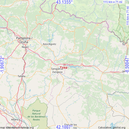
Yesa GPS coordinates[2]
42° 37' 12.9" North, 1° 12' 12.96" West
| Map corner | latitude | longitude |
|---|---|---|
| Upper-left | 43.1355°, | -1.90672° |
| Center: | 42.62025°, | -1.2036° |
| Lower-right: | 42.1007°, | -0.50047° |
| Map W x H: | 115.1×115.1 km | = 71.5×71.5mi |
| max Lat: | 43.74134° ⇑10% North |
| Yesa: | 42.62025° |
| min Lat: | ⇓90% South 27.64134° |
| min Long | Yesa | max Long |
| -18.00367° | -1.2036° | 4.2899° |
| W 75.7%⇐ | ⇒24.3% E |
Elevation
Elevation of Yesa is 497 m = 1631 ft, and this is 101 m = 331 ft below average elevation for this country.
| Max E: |
1682 m = 5518 ft | 62.2% |
| Avg. | 598 m = 1962 ft | |
| Yesa | 497 m = 1631 ft | |
Min E: |
0 m = 0 ft | 37.8% |
See also: Spain elevation on elevation.city.
Geographical zone
Yesa is located in North temperate zone (between Tropic of Cancer and the Arctic Circle). Distance of this Northern Tropic circle is 2133 km =1325.4 mi to South.| Distance of | km | miles | from Yesa |
|---|---|---|---|
| North Pole | 5268.1 | 3273.4 | to North |
| Arctic Circle | 2662.2 | 1654.2 | to North |
| Tropic Cancer | 2133 | 1325.4 | to South |
| Equator | 4738.9 | 2944.6 | to South |


Nearby cities:
15 places around Yesa: (largest is in red/bold)
• Castillonuevo
15.7 km =9.8 mi,  63°
63°
• Cáseda
17.2 km =10.7 mi,  230°
230°
• Javier
3.3 km =2.1 mi,  187°
187°
• Leache
16.7 km =10.4 mi,  265°
265°
• Liédena
5.9 km =3.7 mi, 269°
• Lumbier
9.2 km =5.7 mi,  293°
293°
• Navardún
12.8 km =8 mi,  159°
159°
• Navascués
12.9 km =8 mi,  33°
33°
• Salvatierra de Esca
17.2 km =10.7 mi,  71°
71°
• Sangüesa/Zangoza
8.2 km =5.1 mi, 232°
• Sigüés
15.7 km =9.8 mi,  85°
85°
• Sos del Rey Católico
13.8 km =8.6 mi,  183°
183°
• Undués de Lerda
6.7 km =4.2 mi, 155°
• Urriés
12.7 km =7.9 mi,  151°
151°
• Áibar
13.2 km =8.2 mi,  256°
256°
Sources, notices
• [Note1] Compared only with cities in Spain existing in our database
• [Src1] Map data: © OpenStreetMap contributors (CC-BY-SA)
• [Src2] Other city data from geonames.org with taken over terms of usage.
• [Src3] Geographical zone / Annual Mean Temperature by Robert A. Rohde @ Wikipedia
