Mianos geodata
Mianos (Aragon) is a seat of a third-order administrative division; located in Spain in Europe/Madrid (GMT+2) time zone. With population of 45 people, there are 6517 cities with bigger population in this country. Compared to other cities in Spain, 89.2% of cities are located further ↓South; 77.5% of cities are located further ←West and 53% of cities have higher elevation than Mianos. Note1


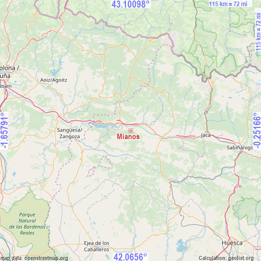
Mianos GPS coordinates[2]
42° 35' 7.584" North, 0° 57' 17.208" West
| Map corner | latitude | longitude |
|---|---|---|
| Upper-left | 43.10098°, | -1.65791° |
| Center: | 42.58544°, | -0.95478° |
| Lower-right: | 42.0656°, | -0.25166° |
| Map W x H: | 115.1×115.1 km | = 71.5×71.5mi |
| max Lat: | 43.74134° ⇑10.8% North |
| Mianos: | 42.58544° |
| min Lat: | ⇓89.2% South 27.64134° |
| min Long | Mianos | max Long |
| -18.00367° | -0.95478° | 4.2899° |
| W 77.5%⇐ | ⇒22.5% E |
Elevation
Elevation of Mianos is 624 m = 2047 ft, and this is 26 m = 85 ft above average elevation for this country.
| Max E: |
1682 m = 5518 ft | 53% |
| Mianos | 624 m 2047 ft | |
| Avg. | 598 m = 1962 ft | |
Min E: |
0 m = 0 ft | 47% |
See also: Spain elevation on elevation.city.
Geographical zone
Mianos is located in North temperate zone (between Tropic of Cancer and the Arctic Circle). Distance of this Northern Tropic circle is 2129.1 km =1323 mi to South.| Distance of | km | miles | from Mianos |
|---|---|---|---|
| North Pole | 5272 | 3275.9 | to North |
| Arctic Circle | 2666.1 | 1656.6 | to North |
| Tropic Cancer | 2129.1 | 1323 | to South |
| Equator | 4735.1 | 2942.3 | to South |


Nearby cities:
15 places around Mianos: (largest is in red/bold)
• Artieda
2.4 km =1.5 mi,  269°
269°
• Bagüés
4.1 km =2.5 mi,  169°
169°
• Bailo
14.5 km =9 mi,  125°
125°
• Castillonuevo
12.5 km =7.8 mi,  329°
329°
• Fago
17.6 km =10.9 mi,  19°
19°
• Isuerre
13.6 km =8.5 mi,  216°
216°
• Lobera de Onsella
13.1 km =8.1 mi,  204°
204°
• Longás
11.7 km =7.3 mi, 171°
• Navardún
17.8 km =11.1 mi,  242°
242°
• Navascués
19.8 km =12.3 mi,  317°
317°
• Puente la Reina de Jaca
14 km =8.7 mi,  102°
102°
• Salvatierra de Esca
10.3 km =6.4 mi,  336°
336°
• Sigüés
6.8 km =4.2 mi, 316°
• Undués de Lerda
17.7 km =11 mi,  262°
262°
• Urriés
16.1 km =10 mi, 242°
Sources, notices
• [Note1] Compared only with cities in Spain existing in our database
• [Src1] Map data: © OpenStreetMap contributors (CC-BY-SA)
• [Src2] Other city data from geonames.org with taken over terms of usage.
• [Src3] Geographical zone / Annual Mean Temperature by Robert A. Rohde @ Wikipedia
