Murillo de Río Leza geodata
Murillo de Río Leza (La Rioja) is a seat of a third-order administrative division; located in Spain in Europe/Madrid (GMT+2) time zone. With population of 1,231 people, there are 2704 cities with bigger population in this country. Compared to other cities in Spain, 84.8% of cities are located further ↓South; 63.1% of cities are located further ←West and 67.9% of cities have higher elevation than Murillo de Río Leza. Note1
Administrative division(s):
- Level 1: La Rioja
- Level 2: Provincia de La Rioja
- Level 3: Murillo de Río Leza


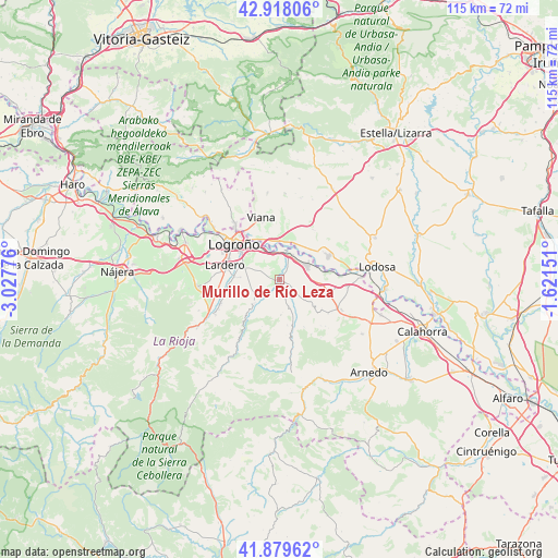
Murillo de Río Leza GPS coordinates[2]
42° 24' 3.564" North, 2° 19' 28.704" West
| Map corner | latitude | longitude |
|---|---|---|
| Upper-left | 42.91806°, | -3.02776° |
| Center: | 42.40099°, | -2.32464° |
| Lower-right: | 41.87962°, | -1.62151° |
| Map W x H: | 115.5×115.5 km | = 71.8×71.8mi |
| max Lat: | 43.74134° ⇑15.2% North |
| Murillo de Río Leza: | 42.40099° |
| min Lat: | ⇓84.8% South 27.64134° |
| min Long | Murillo de Río | max Long |
| -18.00367° | -2.32464° | 4.2899° |
| W 63.1%⇐ | ⇒36.9% E |
Elevation
Elevation of Murillo de Río Leza is 418 m = 1371 ft, and this is 180 m = 591 ft below average elevation for this country.
| Max E: |
1682 m = 5518 ft | 67.9% |
| Avg. | 598 m = 1962 ft | |
| Murillo de Río Leza | 418 m = 1371 ft | |
Min E: |
0 m = 0 ft | 32.1% |
See also: Spain elevation on elevation.city.
Geographical zone
Murillo de Río Leza is located in North temperate zone (between Tropic of Cancer and the Arctic Circle). Distance of this Northern Tropic circle is 2108.6 km =1310.2 mi to South.| Distance of | km | miles | from Murillo de Río Leza |
|---|---|---|---|
| North Pole | 5292.5 | 3288.6 | to North |
| Arctic Circle | 2686.6 | 1669.4 | to North |
| Tropic Cancer | 2108.6 | 1310.2 | to South |
| Equator | 4714.5 | 2929.5 | to South |


Nearby cities:
15 places around Murillo de Río Leza: (largest is in red/bold)
• Agoncillo
5.8 km =3.6 mi,  29°
29°
• Albelda de Iregua
13.1 km =8.1 mi,  248°
248°
• Alberite
9.4 km =5.8 mi,  274°
274°
• Arrúbal
7.1 km =4.4 mi,  57°
57°
• Clavijo
10.2 km =6.3 mi,  235°
235°
• Corera
10.7 km =6.6 mi,  126°
126°
• Galilea
9.4 km =5.8 mi, 129°
• Lagunilla del Jubera
7.4 km =4.6 mi,  177°
177°
• Lardero
11.6 km =7.2 mi,  284°
284°
• Lazagurría
12.3 km =7.6 mi, 34°
• Leza de Río Leza
10.4 km =6.5 mi,  220°
220°
• Logroño
12.6 km =7.8 mi,  305°
305°
• Mendavia
11.2 km =7 mi,  65°
65°
• Ribafrecha
7.4 km =4.6 mi,  226°
226°
• Villamediana de Iregua
8.3 km =5.2 mi,  290°
290°
Sources, notices
• [Note1] Compared only with cities in Spain existing in our database
• [Src1] Map data: © OpenStreetMap contributors (CC-BY-SA)
• [Src2] Other city data from geonames.org with taken over terms of usage.
• [Src3] Geographical zone / Annual Mean Temperature by Robert A. Rohde @ Wikipedia
