Galilea geodata
Galilea (La Rioja) is a seat of a third-order administrative division; located in Spain in Europe/Madrid (GMT+2) time zone. With population of 307 people, there are 4476 cities with bigger population in this country. Compared to other cities in Spain, 83.3% of cities are located further ↓South; 64.3% of cities are located further ←West and 57.5% of cities have higher elevation than Galilea. Note1


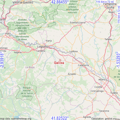
Galilea GPS coordinates[2]
42° 20' 49.308" North, 2° 14' 9.78" West
| Map corner | latitude | longitude |
|---|---|---|
| Upper-left | 42.86455°, | -2.93918° |
| Center: | 42.34703°, | -2.23605° |
| Lower-right: | 41.82522°, | -1.53293° |
| Map W x H: | 115.6×115.6 km | = 71.8×71.8mi |
| max Lat: | 43.74134° ⇑16.7% North |
| Galilea: | 42.34703° |
| min Lat: | ⇓83.3% South 27.64134° |
| min Long | Galilea | max Long |
| -18.00367° | -2.23605° | 4.2899° |
| W 64.3%⇐ | ⇒35.7% E |
Elevation
Elevation of Galilea is 557 m = 1827 ft, and this is 41 m = 135 ft below average elevation for this country.
| Max E: |
1682 m = 5518 ft | 57.5% |
| Avg. | 598 m = 1962 ft | |
| Galilea | 557 m = 1827 ft | |
Min E: |
0 m = 0 ft | 42.5% |
See also: Spain elevation on elevation.city.
Geographical zone
Galilea is located in North temperate zone (between Tropic of Cancer and the Arctic Circle). Distance of this Northern Tropic circle is 2102.6 km =1306.5 mi to South.| Distance of | km | miles | from Galilea |
|---|---|---|---|
| North Pole | 5298.5 | 3292.3 | to North |
| Arctic Circle | 2692.6 | 1673.1 | to North |
| Tropic Cancer | 2102.6 | 1306.5 | to South |
| Equator | 4708.5 | 2925.7 | to South |


Nearby cities:
15 places around Galilea: (largest is in red/bold)
• Agoncillo
11.9 km =7.4 mi,  338°
338°
• Alcanadre
11.5 km =7.1 mi,  55°
55°
• Arrúbal
9.8 km =6.1 mi,  352°
352°
• Ausejo
5.7 km =3.5 mi,  95°
95°
• Bergasa
13.5 km =8.4 mi,  140°
140°
• Bergasillas Bajera
13.1 km =8.1 mi,  150°
150°
• Corera
1.4 km =0.9 mi,  107°
107°
• El Villar de Arnedo
11.9 km =7.4 mi, 104°
• Lagunilla del Jubera
7.1 km =4.4 mi,  258°
258°
• Mendavia
11.1 km =6.9 mi,  15°
15°
• Murillo de Río Leza
9.4 km =5.8 mi,  309°
309°
• Ocón
5.4 km =3.4 mi,  183°
183°
• Ribafrecha
12.7 km =7.9 mi,  274°
274°
• Robres del Castillo
9.2 km =5.7 mi,  210°
210°
• Tudelilla
11 km =6.8 mi,  118°
118°
Sources, notices
• [Note1] Compared only with cities in Spain existing in our database
• [Src1] Map data: © OpenStreetMap contributors (CC-BY-SA)
• [Src2] Other city data from geonames.org with taken over terms of usage.
• [Src3] Geographical zone / Annual Mean Temperature by Robert A. Rohde @ Wikipedia
