Clavijo geodata
Clavijo (La Rioja) is a seat of a third-order administrative division; located in Spain in Europe/Madrid (GMT+2) time zone. With population of 263 people, there are 4672 cities with bigger population in this country. Compared to other cities in Spain, 83.3% of cities are located further ↓South; 61.9% of cities are located further ←West and 77.1% of cities have lower elevation than Clavijo. Note1


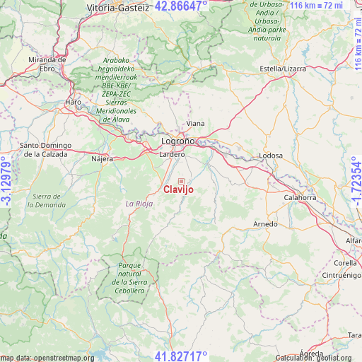
Clavijo GPS coordinates[2]
42° 20' 56.292" North, 2° 25' 35.976" West
| Map corner | latitude | longitude |
|---|---|---|
| Upper-left | 42.86647°, | -3.12979° |
| Center: | 42.34897°, | -2.42666° |
| Lower-right: | 41.82717°, | -1.72354° |
| Map W x H: | 115.6×115.6 km | = 71.8×71.8mi |
| max Lat: | 43.74134° ⇑16.7% North |
| Clavijo: | 42.34897° |
| min Lat: | ⇓83.3% South 27.64134° |
| min Long | Clavijo | max Long |
| -18.00367° | -2.42666° | 4.2899° |
| W 61.9%⇐ | ⇒38.1% E |
Elevation
Elevation of Clavijo is 871 m = 2858 ft, and this is 273 m = 896 ft above average elevation for this country.
| Max E: |
1682 m = 5518 ft | 22.9% |
| Clavijo | 871 m 2858 ft | |
| Avg. | 598 m = 1962 ft | |
Min E: |
0 m = 0 ft | 77.1% |
See also: Spain elevation on elevation.city.
Geographical zone
Clavijo is located in North temperate zone (between Tropic of Cancer and the Arctic Circle). Distance of this Northern Tropic circle is 2102.8 km =1306.6 mi to South.| Distance of | km | miles | from Clavijo |
|---|---|---|---|
| North Pole | 5298.3 | 3292.2 | to North |
| Arctic Circle | 2692.4 | 1673 | to North |
| Tropic Cancer | 2102.8 | 1306.6 | to South |
| Equator | 4708.8 | 2925.9 | to South |


Nearby cities:
15 places around Clavijo: (largest is in red/bold)
• Albelda de Iregua
3.9 km =2.4 mi,  285°
285°
• Alberite
6.5 km =4 mi,  351°
351°
• Entrena
9.6 km =6 mi,  296°
296°
• Lagunilla del Jubera
8.8 km =5.5 mi,  100°
100°
• Lardero
9.1 km =5.7 mi,  341°
341°
• Leza de Río Leza
2.7 km =1.7 mi,  141°
141°
• Murillo de Río Leza
10.2 km =6.3 mi,  55°
55°
• Nalda
5.2 km =3.2 mi,  252°
252°
• Ribafrecha
3.1 km =1.9 mi,  76°
76°
• Sojuela
10 km =6.2 mi,  283°
283°
• Sorzano
8.4 km =5.2 mi,  265°
265°
• Soto en Cameros
7 km =4.3 mi,  179°
179°
• Terroba
10.2 km =6.3 mi,  187°
187°
• Viguera
9.8 km =6.1 mi,  243°
243°
• Villamediana de Iregua
8.6 km =5.3 mi,  3°
3°
Sources, notices
• [Note1] Compared only with cities in Spain existing in our database
• [Src1] Map data: © OpenStreetMap contributors (CC-BY-SA)
• [Src2] Other city data from geonames.org with taken over terms of usage.
• [Src3] Geographical zone / Annual Mean Temperature by Robert A. Rohde @ Wikipedia
