Mungia geodata
Mungia (Basque Country) is a seat of a third-order administrative division; located in Spain in Europe/Madrid (GMT+2) time zone. With population of 16,209 people, there are 584 cities with bigger population in this country. Compared to other cities in Spain, 98.3% of cities are located further ↓South; 56.8% of cities are located further ←West and 93.3% of cities have higher elevation than Mungia. Note1


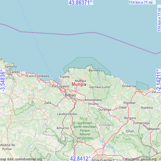
Mungia GPS coordinates[2]
43° 21' 16.596" North, 2° 50' 42.864" West
| Map corner | latitude | longitude |
|---|---|---|
| Upper-left | 43.86371°, | -3.54836° |
| Center: | 43.35461°, | -2.84524° |
| Lower-right: | 42.8412°, | -2.14211° |
| Map W x H: | 113.7×113.7 km | = 70.6×70.6mi |
| max Lat: | 43.74134° ⇑1.7% North |
| Mungia: | 43.35461° |
| min Lat: | ⇓98.3% South 27.64134° |
| min Long | Mungia | max Long |
| -18.00367° | -2.84524° | 4.2899° |
| W 56.8%⇐ | ⇒43.2% E |
Elevation
Elevation of Mungia is 36 m = 118 ft, and this is 562 m = 1844 ft below average elevation for this country.
| Max E: |
1682 m = 5518 ft | 93.3% |
| Avg. | 598 m = 1962 ft | |
| Mungia | 36 m = 118 ft | |
Min E: |
0 m = 0 ft | 6.7% |
See also: Spain elevation on elevation.city.
Geographical zone
Mungia is located in North temperate zone (between Tropic of Cancer and the Arctic Circle). Distance of this Northern Tropic circle is 2214.7 km =1376.2 mi to South.| Distance of | km | miles | from Mungia |
|---|---|---|---|
| North Pole | 5186.5 | 3222.7 | to North |
| Arctic Circle | 2580.6 | 1603.5 | to North |
| Tropic Cancer | 2214.7 | 1376.2 | to South |
| Equator | 4820.6 | 2995.4 | to South |


Nearby cities:
15 places around Mungia: (largest is in red/bold)
• Bakio
8.8 km =5.5 mi,  19°
19°
• Berango
12.2 km =7.6 mi,  275°
275°
• Bilbao
12.1 km =7.5 mi,  212°
212°
• Derio
6.2 km =3.9 mi, 207°
• Elexalde
10 km =6.2 mi,  312°
312°
• Erandio
11.8 km =7.3 mi,  241°
241°
• Erandiogoikoa
10.2 km =6.3 mi, 239°
• Errigoiti
11.2 km =7 mi,  112°
112°
• Gatika
2.4 km =1.5 mi,  292°
292°
• Landa
9 km =5.6 mi, 290°
• Leioa
12 km =7.5 mi,  255°
255°
• Plentzia
10 km =6.2 mi,  304°
304°
• Sondika
8.8 km =5.5 mi,  226°
226°
• Sopela
11.5 km =7.1 mi, 283°
• Zamudio
7.9 km =4.9 mi,  194°
194°
Sources, notices
• [Note1] Compared only with cities in Spain existing in our database
• [Src1] Map data: © OpenStreetMap contributors (CC-BY-SA)
• [Src2] Other city data from geonames.org with taken over terms of usage.
• [Src3] Geographical zone / Annual Mean Temperature by Robert A. Rohde @ Wikipedia
