Sopela geodata
Sopela (Basque Country) is a seat of a third-order administrative division; located in Spain in Europe/Madrid (GMT+2) time zone. With population of 12,359 people, there are 734 cities with bigger population in this country. Compared to other cities in Spain, 98.6% of cities are located further ↓South; 54.8% of cities are located further ←West and 91.1% of cities have higher elevation than Sopela. Note1


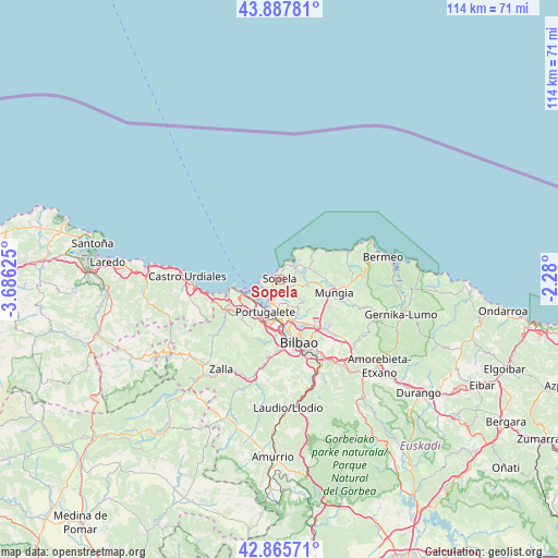
Sopela GPS coordinates[2]
43° 22' 44.076" North, 2° 58' 59.268" West
| Map corner | latitude | longitude |
|---|---|---|
| Upper-left | 43.88781°, | -3.68625° |
| Center: | 43.37891°, | -2.98313° |
| Lower-right: | 42.86571°, | -2.28° |
| Map W x H: | 113.6×113.6 km | = 70.6×70.6mi |
| max Lat: | 43.74134° ⇑1.4% North |
| Sopela: | 43.37891° |
| min Lat: | ⇓98.6% South 27.64134° |
| min Long | Sopela | max Long |
| -18.00367° | -2.98313° | 4.2899° |
| W 54.8%⇐ | ⇒45.2% E |
Elevation
Elevation of Sopela is 51 m = 167 ft, and this is 547 m = 1795 ft below average elevation for this country.
| Max E: |
1682 m = 5518 ft | 91.1% |
| Avg. | 598 m = 1962 ft | |
| Sopela | 51 m = 167 ft | |
Min E: |
0 m = 0 ft | 8.9% |
See also: Spain elevation on elevation.city.
Geographical zone
Sopela is located in North temperate zone (between Tropic of Cancer and the Arctic Circle). Distance of this Northern Tropic circle is 2217.4 km =1377.8 mi to South.| Distance of | km | miles | from Sopela |
|---|---|---|---|
| North Pole | 5183.8 | 3221.1 | to North |
| Arctic Circle | 2577.9 | 1601.8 | to North |
| Tropic Cancer | 2217.4 | 1377.8 | to South |
| Equator | 4823.3 | 2997.1 | to South |


Nearby cities:
15 places around Sopela: (largest is in red/bold)
• Algorta
3.9 km =2.4 mi,  212°
212°
• Barakaldo
9.2 km =5.7 mi,  182°
182°
• Berango
1.9 km =1.2 mi, 213°
• Elexalde
5.5 km =3.4 mi,  43°
43°
• Erandio
8.3 km =5.2 mi,  174°
174°
• Erandiogoikoa
8.3 km =5.2 mi,  163°
163°
• Gatika
9.1 km =5.7 mi,  101°
101°
• Getxo
3.4 km =2.1 mi,  223°
223°
• Landa
2.7 km =1.7 mi,  79°
79°
• Leioa
5.8 km =3.6 mi, 184°
• Plentzia
4.1 km =2.5 mi, 44°
• Portugalete
7.1 km =4.4 mi, 205°
• Santurtzi
6.9 km =4.3 mi, 215°
• Sestao
7.9 km =4.9 mi,  194°
194°
• Zierbena
8.7 km =5.4 mi,  248°
248°
Sources, notices
• [Note1] Compared only with cities in Spain existing in our database
• [Src1] Map data: © OpenStreetMap contributors (CC-BY-SA)
• [Src2] Other city data from geonames.org with taken over terms of usage.
• [Src3] Geographical zone / Annual Mean Temperature by Robert A. Rohde @ Wikipedia
