Bakio geodata
Bakio (Basque Country) is a seat of a third-order administrative division; located in Spain in Europe/Madrid (GMT+2) time zone. In our database, there are 6762 cities with bigger population. Compared to other cities in Spain, 99.1% of cities are located further ↓South; 57.3% of cities are located further ←West and 99.6% of cities have higher elevation than Bakio. Note1


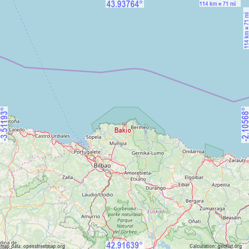
Bakio GPS coordinates[2]
43° 25' 45.012" North, 2° 48' 31.716" West
| Map corner | latitude | longitude |
|---|---|---|
| Upper-left | 43.93764°, | -3.51193° |
| Center: | 43.42917°, | -2.80881° |
| Lower-right: | 42.91639°, | -2.10568° |
| Map W x H: | 113.6×113.6 km | = 70.6×70.6mi |
| max Lat: | 43.74134° ⇑0.9% North |
| Bakio: | 43.42917° |
| min Lat: | ⇓99.1% South 27.64134° |
| min Long | Bakio | max Long |
| -18.00367° | -2.80881° | 4.2899° |
| W 57.3%⇐ | ⇒42.7% E |
Elevation
Elevation of Bakio is 5 m = 16 ft, and this is 593 m = 1946 ft below average elevation for this country.
| Max E: |
1682 m = 5518 ft | 99.6% |
| Avg. | 598 m = 1962 ft | |
| Bakio | 5 m = 16 ft | |
Min E: |
0 m = 0 ft | 0.4% |
See also: Spain elevation on elevation.city.
Geographical zone
Bakio is located in North temperate zone (between Tropic of Cancer and the Arctic Circle). Distance of this Northern Tropic circle is 2223 km =1381.3 mi to South.| Distance of | km | miles | from Bakio |
|---|---|---|---|
| North Pole | 5178.2 | 3217.6 | to North |
| Arctic Circle | 2572.3 | 1598.4 | to North |
| Tropic Cancer | 2223 | 1381.3 | to South |
| Equator | 4828.9 | 3000.5 | to South |


Nearby cities:
15 places around Bakio: (largest is in red/bold)
• Axpe de Busturia
10.3 km =6.4 mi,  119°
119°
• Bermeo
7.1 km =4.4 mi,  97°
97°
• Derio
14.9 km =9.3 mi,  203°
203°
• Elantxobe
14 km =8.7 mi, 102°
• Elexalde
10.5 km =6.5 mi,  261°
261°
• Errigoiti
14.6 km =9.1 mi,  149°
149°
• Forua
15.2 km =9.4 mi,  134°
134°
• Gatika
9 km =5.6 mi,  215°
215°
• Gernika-Lumo
16.1 km =10 mi,  140°
140°
• Ibarrangelu
14.8 km =9.2 mi,  107°
107°
• Landa
12.5 km =7.8 mi,  245°
245°
• Mundaka
9.2 km =5.7 mi, 104°
• Mungia
8.8 km =5.5 mi, 199°
• Plentzia
11.5 km =7.1 mi, 256°
• Sopela
15.2 km =9.4 mi, 248°
Sources, notices
• [Note1] Compared only with cities in Spain existing in our database
• [Src1] Map data: © OpenStreetMap contributors (CC-BY-SA)
• [Src2] Other city data from geonames.org with taken over terms of usage.
• [Src3] Geographical zone / Annual Mean Temperature by Robert A. Rohde @ Wikipedia
