Plentzia geodata
Plentzia (Basque Country) is a seat of a third-order administrative division; located in Spain in Europe/Madrid (GMT+2) time zone. In our database, there are 6762 cities with bigger population. Compared to other cities in Spain, 98.9% of cities are located further ↓South; 55.4% of cities are located further ←West and 96.6% of cities have higher elevation than Plentzia. Note1


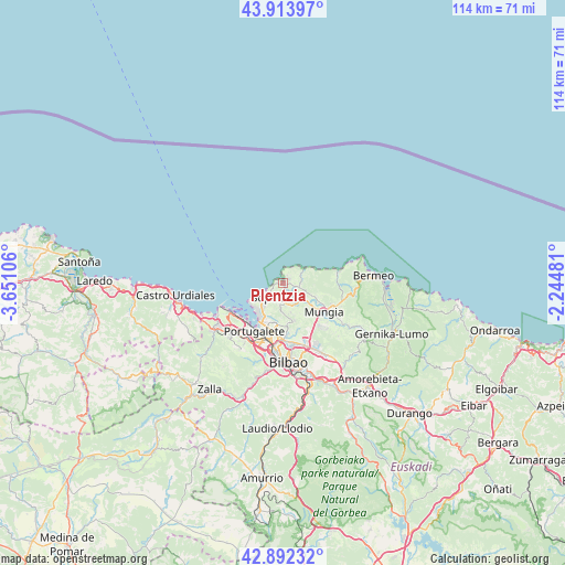
Plentzia GPS coordinates[2]
43° 24' 19.08" North, 2° 56' 52.584" West
| Map corner | latitude | longitude |
|---|---|---|
| Upper-left | 43.91397°, | -3.65106° |
| Center: | 43.4053°, | -2.94794° |
| Lower-right: | 42.89232°, | -2.24481° |
| Map W x H: | 113.6×113.6 km | = 70.6×70.6mi |
| max Lat: | 43.74134° ⇑1.1% North |
| Plentzia: | 43.4053° |
| min Lat: | ⇓98.9% South 27.64134° |
| min Long | Plentzia | max Long |
| -18.00367° | -2.94794° | 4.2899° |
| W 55.4%⇐ | ⇒44.6% E |
Elevation
Elevation of Plentzia is 17 m = 56 ft, and this is 581 m = 1906 ft below average elevation for this country.
| Max E: |
1682 m = 5518 ft | 96.6% |
| Avg. | 598 m = 1962 ft | |
| Plentzia | 17 m = 56 ft | |
Min E: |
0 m = 0 ft | 3.4% |
See also: Spain elevation on elevation.city.
Geographical zone
Plentzia is located in North temperate zone (between Tropic of Cancer and the Arctic Circle). Distance of this Northern Tropic circle is 2220.3 km =1379.6 mi to South.| Distance of | km | miles | from Plentzia |
|---|---|---|---|
| North Pole | 5180.8 | 3219.2 | to North |
| Arctic Circle | 2575 | 1600 | to North |
| Tropic Cancer | 2220.3 | 1379.6 | to South |
| Equator | 4826.2 | 2998.9 | to South |


Nearby cities:
15 places around Plentzia: (largest is in red/bold)
• Algorta
8 km =5 mi,  218°
218°
• Bakio
11.5 km =7.1 mi,  76°
76°
• Berango
5.9 km =3.7 mi, 220°
• Elexalde
1.4 km =0.9 mi,  40°
40°
• Erandio
11.4 km =7.1 mi,  190°
190°
• Erandiogoikoa
10.9 km =6.8 mi,  182°
182°
• Gatika
7.7 km =4.8 mi,  127°
127°
• Getxo
7.4 km =4.6 mi, 223°
• Landa
2.4 km =1.5 mi, 183°
• Leioa
9.3 km =5.8 mi,  200°
200°
• Mungia
10 km =6.2 mi,  124°
124°
• Portugalete
11.1 km =6.9 mi,  212°
212°
• Santurtzi
10.9 km =6.8 mi, 218°
• Sestao
11.7 km =7.3 mi, 204°
• Sopela
4.1 km =2.5 mi, 224°
Sources, notices
• [Note1] Compared only with cities in Spain existing in our database
• [Src1] Map data: © OpenStreetMap contributors (CC-BY-SA)
• [Src2] Other city data from geonames.org with taken over terms of usage.
• [Src3] Geographical zone / Annual Mean Temperature by Robert A. Rohde @ Wikipedia
