Montgat geodata
Montgat (Catalonia) is a seat of a third-order administrative division; located in Spain in Europe/Madrid (GMT+2) time zone. With population of 10,270 people, there are 843 cities with bigger population in this country. Compared to other cities in Spain, 60% of cities are located further ↓South; 95.8% of cities are located further ←West and 90.9% of cities have higher elevation than Montgat. Note1


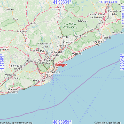
Montgat GPS coordinates[2]
41° 28' 6.924" North, 2° 16' 48.036" East
| Map corner | latitude | longitude |
|---|---|---|
| Upper-left | 41.99331°, | 1.57689° |
| Center: | 41.46859°, | 2.28001° |
| Lower-right: | 40.93959°, | 2.98314° |
| Map W x H: | 117.2×117.2 km | = 72.8×72.8mi |
| max Lat: | 43.74134° ⇑40% North |
| Montgat: | 41.46859° |
| min Lat: | ⇓60% South 27.64134° |
| min Long | Montgat | max Long |
| -18.00367° | 2.28001° | 4.2899° |
| W 95.8%⇐ | ⇒4.2% E |
Elevation
Elevation of Montgat is 53 m = 174 ft, and this is 545 m = 1788 ft below average elevation for this country.
| Max E: |
1682 m = 5518 ft | 90.9% |
| Avg. | 598 m = 1962 ft | |
| Montgat | 53 m = 174 ft | |
Min E: |
0 m = 0 ft | 9.1% |
See also: Spain elevation on elevation.city.
Geographical zone
Montgat is located in North temperate zone (between Tropic of Cancer and the Arctic Circle). Distance of this Northern Tropic circle is 2005 km =1245.8 mi to South.| Distance of | km | miles | from Montgat |
|---|---|---|---|
| North Pole | 5396.2 | 3353 | to North |
| Arctic Circle | 2790.3 | 1733.8 | to North |
| Tropic Cancer | 2005 | 1245.8 | to South |
| Equator | 4610.9 | 2865.1 | to South |


Nearby cities:
15 places around Montgat: (largest is in red/bold)
• Alella
3.1 km =1.9 mi,  23°
23°
• Badalona
3.4 km =2.1 mi,  232°
232°
• Baró de Viver
7.2 km =4.5 mi,  249°
249°
• El Masnou
3.5 km =2.2 mi,  68°
68°
• Llefià
6.1 km =3.8 mi,  236°
236°
• Premià de Mar
7.6 km =4.7 mi, 69°
• Sant Adrià de Besòs
6.6 km =4.1 mi, 230°
• Santa Coloma de Gramenet
6.3 km =3.9 mi, 252°
• Teià
4.8 km =3 mi,  46°
46°
• Tiana
1.8 km =1.1 mi,  324°
324°
• Vallbona
8 km =5 mi,  265°
265°
• Vallromanes
7.4 km =4.6 mi,  13°
13°
• el Besòs i el Maresme
8.1 km =5 mi,  220°
220°
• el Bon Pastor
7.4 km =4.6 mi, 241°
• la Trinitat Vella
7.5 km =4.7 mi,  255°
255°
Sources, notices
• [Note1] Compared only with cities in Spain existing in our database
• [Src1] Map data: © OpenStreetMap contributors (CC-BY-SA)
• [Src2] Other city data from geonames.org with taken over terms of usage.
• [Src3] Geographical zone / Annual Mean Temperature by Robert A. Rohde @ Wikipedia
