Meco geodata
Meco (Madrid) is a seat of a third-order administrative division; located in Spain in Europe/Madrid (GMT+2) time zone. With population of 12,419 people, there are 733 cities with bigger population in this country. Compared to other cities in Spain, 60.8% of cities are located further ↑North; 50.1% of cities are located further ←West and 50.5% of cities have lower elevation than Meco. Note1


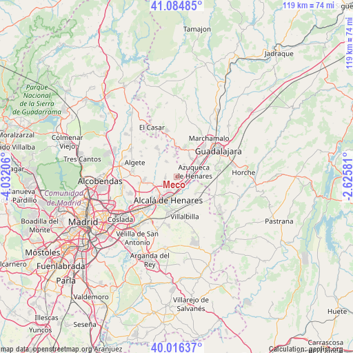
Meco GPS coordinates[2]
40° 33' 9.864" North, 3° 19' 44.184" West
| Map corner | latitude | longitude |
|---|---|---|
| Upper-left | 41.08485°, | -4.03206° |
| Center: | 40.55274°, | -3.32894° |
| Lower-right: | 40.01637°, | -2.62581° |
| Map W x H: | 118.8×118.8 km | = 73.8×73.8mi |
| max Lat: | 43.74134° ⇑60.8% North |
| Meco: | 40.55274° |
| min Lat: | ⇓39.2% South 27.64134° |
| min Long | Meco | max Long |
| -18.00367° | -3.32894° | 4.2899° |
| W 50.1%⇐ | ⇒49.9% E |
Elevation
Elevation of Meco is 664 m = 2178 ft, and this is 66 m = 217 ft above average elevation for this country.
| Max E: |
1682 m = 5518 ft | 49.5% |
| Meco | 664 m 2178 ft | |
| Avg. | 598 m = 1962 ft | |
Min E: |
0 m = 0 ft | 50.5% |
See also: Spain elevation on elevation.city.
Geographical zone
Meco is located in North temperate zone (between Tropic of Cancer and the Arctic Circle). Distance of this Northern Tropic circle is 1903.1 km =1182.5 mi to South.| Distance of | km | miles | from Meco |
|---|---|---|---|
| North Pole | 5498 | 3416.3 | to North |
| Arctic Circle | 2892.1 | 1797.1 | to North |
| Tropic Cancer | 1903.1 | 1182.5 | to South |
| Equator | 4509 | 2801.8 | to South |


Nearby cities:
15 places around Meco: (largest is in red/bold)
• Alcalá de Henares
8.3 km =5.2 mi,  198°
198°
• Alovera
8.4 km =5.2 mi,  57°
57°
• Anchuelo
11 km =6.8 mi,  152°
152°
• Azuqueca de Henares
5.4 km =3.4 mi,  74°
74°
• Cabanillas del Campo
12.3 km =7.6 mi,  43°
43°
• Camarma de Esteruelas
3.7 km =2.3 mi,  265°
265°
• Daganzo de Arriba
10.7 km =6.6 mi,  264°
264°
• Fresno de Torote
8 km =5 mi,  301°
301°
• Los Santos de la Humosa
8.7 km =5.4 mi,  132°
132°
• Quer
7.4 km =4.6 mi, 37°
• Santorcaz
12 km =7.5 mi,  138°
138°
• Torrejón del Rey
10.1 km =6.3 mi,  357°
357°
• Valdeavero
8.6 km =5.3 mi, 359°
• Valdeaveruelo
9.2 km =5.7 mi,  8°
8°
• Villanueva de la Torre
4.2 km =2.6 mi, 38°
Sources, notices
• [Note1] Compared only with cities in Spain existing in our database
• [Src1] Map data: © OpenStreetMap contributors (CC-BY-SA)
• [Src2] Other city data from geonames.org with taken over terms of usage.
• [Src3] Geographical zone / Annual Mean Temperature by Robert A. Rohde @ Wikipedia
