Alovera geodata
Alovera (Castille-La Mancha) is a seat of a third-order administrative division; located in Spain in Europe/Madrid (GMT+2) time zone. With population of 10,734 people, there are 815 cities with bigger population in this country. Compared to other cities in Spain, 59.9% of cities are located further ↑North; 51% of cities are located further ←West and 51.4% of cities have higher elevation than Alovera. Note1
Administrative division(s):
- Level 1: Castille-La Mancha
- Level 2: Provincia de Guadalajara
- Level 3: Alovera


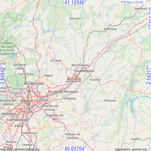
Alovera GPS coordinates[2]
40° 35' 37.248" North, 3° 14' 43.044" West
| Map corner | latitude | longitude |
|---|---|---|
| Upper-left | 41.12546°, | -3.94842° |
| Center: | 40.59368°, | -3.24529° |
| Lower-right: | 40.05764°, | -2.54217° |
| Map W x H: | 118.7×118.7 km | = 73.8×73.8mi |
| max Lat: | 43.74134° ⇑59.9% North |
| Alovera: | 40.59368° |
| min Lat: | ⇓40.1% South 27.64134° |
| min Long | Alovera | max Long |
| -18.00367° | -3.24529° | 4.2899° |
| W 51%⇐ | ⇒49% E |
Elevation
Elevation of Alovera is 644 m = 2113 ft, and this is 46 m = 151 ft above average elevation for this country.
| Max E: |
1682 m = 5518 ft | 51.4% |
| Alovera | 644 m 2113 ft | |
| Avg. | 598 m = 1962 ft | |
Min E: |
0 m = 0 ft | 48.6% |
See also: Spain elevation on elevation.city.
Geographical zone
Alovera is located in North temperate zone (between Tropic of Cancer and the Arctic Circle). Distance of this Northern Tropic circle is 1907.7 km =1185.4 mi to South.| Distance of | km | miles | from Alovera |
|---|---|---|---|
| North Pole | 5493.5 | 3413.5 | to North |
| Arctic Circle | 2887.6 | 1794.3 | to North |
| Tropic Cancer | 1907.7 | 1185.4 | to South |
| Equator | 4513.6 | 2804.6 | to South |


Nearby cities:
15 places around Alovera: (largest is in red/bold)
• Azuqueca de Henares
3.6 km =2.2 mi,  211°
211°
• Cabanillas del Campo
4.7 km =2.9 mi,  16°
16°
• Camarma de Esteruelas
11.8 km =7.3 mi,  245°
245°
• Chiloeches
7.7 km =4.8 mi,  109°
109°
• Guadalajara
8 km =5 mi,  61°
61°
• Los Santos de la Humosa
10.5 km =6.5 mi,  183°
183°
• Marchamalo
9 km =5.6 mi,  25°
25°
• Meco
8.4 km =5.2 mi,  237°
237°
• Pozo de Guadalajara
12.2 km =7.6 mi,  153°
153°
• Quer
2.8 km =1.7 mi,  297°
297°
• Torrejón del Rey
9.3 km =5.8 mi,  306°
306°
• Valdarachas
13.2 km =8.2 mi,  130°
130°
• Valdeavero
8.2 km =5.1 mi, 299°
• Valdeaveruelo
7.4 km =4.6 mi, 308°
• Villanueva de la Torre
4.6 km =2.9 mi, 253°
Sources, notices
• [Note1] Compared only with cities in Spain existing in our database
• [Src1] Map data: © OpenStreetMap contributors (CC-BY-SA)
• [Src2] Other city data from geonames.org with taken over terms of usage.
• [Src3] Geographical zone / Annual Mean Temperature by Robert A. Rohde @ Wikipedia
