Santorcaz geodata
Santorcaz (Madrid) is a seat of a third-order administrative division; located in Spain in Europe/Madrid (GMT+2) time zone. With population of 729 people, there are 3348 cities with bigger population in this country. Compared to other cities in Spain, 62.4% of cities are located further ↑North; 51.2% of cities are located further ←West and 78.3% of cities have lower elevation than Santorcaz. Note1


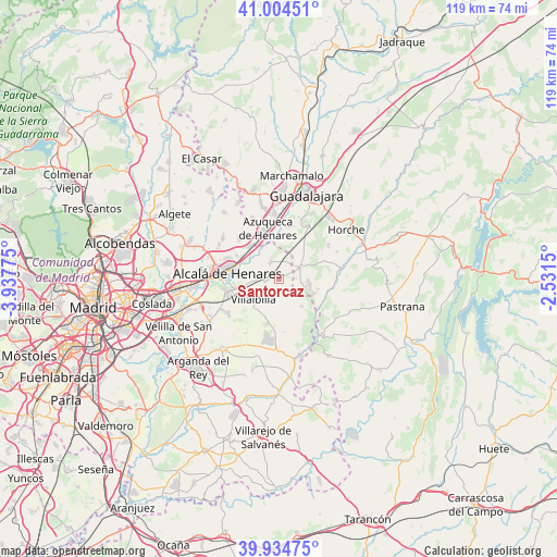
Santorcaz GPS coordinates[2]
40° 28' 18.336" North, 3° 14' 4.632" West
| Map corner | latitude | longitude |
|---|---|---|
| Upper-left | 41.00451°, | -3.93775° |
| Center: | 40.47176°, | -3.23462° |
| Lower-right: | 39.93475°, | -2.5315° |
| Map W x H: | 118.9×118.9 km | = 73.9×73.9mi |
| max Lat: | 43.74134° ⇑62.4% North |
| Santorcaz: | 40.47176° |
| min Lat: | ⇓37.6% South 27.64134° |
| min Long | Santorcaz | max Long |
| -18.00367° | -3.23462° | 4.2899° |
| W 51.2%⇐ | ⇒48.8% E |
Elevation
Elevation of Santorcaz is 882 m = 2894 ft, and this is 284 m = 932 ft above average elevation for this country.
| Max E: |
1682 m = 5518 ft | 21.7% |
| Santorcaz | 882 m 2894 ft | |
| Avg. | 598 m = 1962 ft | |
Min E: |
0 m = 0 ft | 78.3% |
See also: Spain elevation on elevation.city.
Geographical zone
Santorcaz is located in North temperate zone (between Tropic of Cancer and the Arctic Circle). Distance of this Northern Tropic circle is 1894.1 km =1176.9 mi to South.| Distance of | km | miles | from Santorcaz |
|---|---|---|---|
| North Pole | 5507 | 3421.9 | to North |
| Arctic Circle | 2901.1 | 1802.7 | to North |
| Tropic Cancer | 1894.1 | 1176.9 | to South |
| Equator | 4500 | 2796.2 | to South |


Nearby cities:
15 places around Santorcaz: (largest is in red/bold)
• Alcalá de Henares
10.7 km =6.6 mi,  276°
276°
• Anchuelo
2.9 km =1.8 mi,  255°
255°
• Azuqueca de Henares
10.8 km =6.7 mi,  345°
345°
• Chiloeches
12.6 km =7.8 mi,  29°
29°
• Corpa
5.8 km =3.6 mi,  201°
201°
• Loranca de Tajuña
10.9 km =6.8 mi,  106°
106°
• Los Santos de la Humosa
3.5 km =2.2 mi,  333°
333°
• Meco
12 km =7.5 mi,  318°
318°
• Nuevo Baztán
11.6 km =7.2 mi,  182°
182°
• Pezuela de las Torres
8.1 km =5 mi,  140°
140°
• Pioz
5.4 km =3.4 mi,  102°
102°
• Pozo de Guadalajara
5.2 km =3.2 mi,  59°
59°
• Valdarachas
10.4 km =6.5 mi, 61°
• Valverde de Alcalá
8 km =5 mi,  220°
220°
• Villalbilla
7.1 km =4.4 mi,  229°
229°
Sources, notices
• [Note1] Compared only with cities in Spain existing in our database
• [Src1] Map data: © OpenStreetMap contributors (CC-BY-SA)
• [Src2] Other city data from geonames.org with taken over terms of usage.
• [Src3] Geographical zone / Annual Mean Temperature by Robert A. Rohde @ Wikipedia
