Masueco geodata
Masueco (Castille and León) is a seat of a third-order administrative division; located in Spain in Europe/Madrid (GMT+2) time zone. With population of 414 people, there are 4096 cities with bigger population in this country. Compared to other cities in Spain, 53.1% of cities are located further ↓South; 91.8% of cities are located further →East and 52.9% of cities have lower elevation than Masueco. Note1
Administrative division(s):
- Level 1: Castille and León
- Level 2: Provincia de Salamanca
- Level 3: Masueco


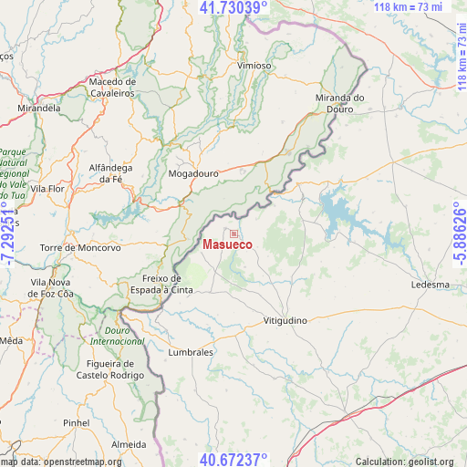
Masueco GPS coordinates[2]
41° 12' 12.672" North, 6° 35' 21.768" West
| Map corner | latitude | longitude |
|---|---|---|
| Upper-left | 41.73039°, | -7.29251° |
| Center: | 41.20352°, | -6.58938° |
| Lower-right: | 40.67237°, | -5.88626° |
| Map W x H: | 117.6×117.6 km | = 73.1×73.1mi |
| max Lat: | 43.74134° ⇑46.9% North |
| Masueco: | 41.20352° |
| min Lat: | ⇓53.1% South 27.64134° |
| min Long | Masueco | max Long |
| -18.00367° | -6.58938° | 4.2899° |
| W 8.2%⇐ | ⇒91.8% E |
Elevation
Elevation of Masueco is 689 m = 2260 ft, and this is 91 m = 299 ft above average elevation for this country.
| Max E: |
1682 m = 5518 ft | 47.1% |
| Masueco | 689 m 2260 ft | |
| Avg. | 598 m = 1962 ft | |
Min E: |
0 m = 0 ft | 52.9% |
See also: Spain elevation on elevation.city.
Geographical zone
Masueco is located in North temperate zone (between Tropic of Cancer and the Arctic Circle). Distance of this Northern Tropic circle is 1975.5 km =1227.5 mi to South.| Distance of | km | miles | from Masueco |
|---|---|---|---|
| North Pole | 5425.7 | 3371.4 | to North |
| Arctic Circle | 2819.8 | 1752.1 | to North |
| Tropic Cancer | 1975.5 | 1227.5 | to South |
| Equator | 4581.4 | 2846.7 | to South |


Nearby cities:
15 places around Masueco: (largest is in red/bold)
• Ahigal de Villarino
18.2 km =11.3 mi,  106°
106°
• Aldeadávila de la Ribera
2.9 km =1.8 mi,  303°
303°
• Barceo
19.6 km =12.2 mi,  143°
143°
• Barruecopardo
15.9 km =9.9 mi,  203°
203°
• Cabeza del Caballo
8.6 km =5.3 mi,  161°
161°
• Cerezal de Peñahorcada
9.7 km =6 mi,  213°
213°
• Mieza
9.6 km =6 mi,  242°
242°
• Sanchón de la Ribera
19.5 km =12.1 mi,  130°
130°
• Trabanca
17.4 km =10.8 mi,  79°
79°
• Valderrodrigo
16.8 km =10.4 mi, 156°
• Valsalabroso
12.7 km =7.9 mi,  145°
145°
• Villar de Samaniego
16.2 km =10.1 mi, 126°
• Villarino de los Aires
12.6 km =7.8 mi,  53°
53°
• Villasbuenas
15.7 km =9.8 mi,  182°
182°
• Vilvestre
15.8 km =9.8 mi,  226°
226°
Sources, notices
• [Note1] Compared only with cities in Spain existing in our database
• [Src1] Map data: © OpenStreetMap contributors (CC-BY-SA)
• [Src2] Other city data from geonames.org with taken over terms of usage.
• [Src3] Geographical zone / Annual Mean Temperature by Robert A. Rohde @ Wikipedia
