Lledó geodata
Lledó (Aragon) is a seat of a third-order administrative division; located in Spain in Europe/Madrid (GMT+2) time zone. With population of 183 people, there are 5165 cities with bigger population in this country. Compared to other cities in Spain, 52.7% of cities are located further ↑North; 88.2% of cities are located further ←West and 65% of cities have higher elevation than Lledó. Note1


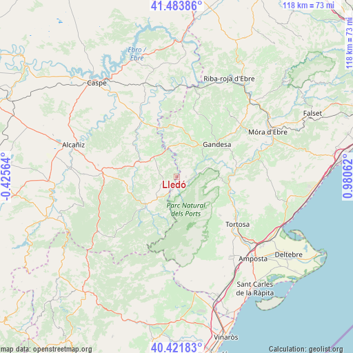
Lledó GPS coordinates[2]
40° 57' 17.928" North, 0° 16' 38.964" East
| Map corner | latitude | longitude |
|---|---|---|
| Upper-left | 41.48386°, | -0.42564° |
| Center: | 40.95498°, | 0.27749° |
| Lower-right: | 40.42183°, | 0.98062° |
| Map W x H: | 118.1×118.1 km | = 73.4×73.4mi |
| max Lat: | 43.74134° ⇑52.7% North |
| Lledó: | 40.95498° |
| min Lat: | ⇓47.3% South 27.64134° |
| min Long | Lledó | max Long |
| -18.00367° | 0.27749° | 4.2899° |
| W 88.2%⇐ | ⇒11.8% E |
Elevation
Elevation of Lledó is 460 m = 1509 ft, and this is 138 m = 453 ft below average elevation for this country.
| Max E: |
1682 m = 5518 ft | 65% |
| Avg. | 598 m = 1962 ft | |
| Lledó | 460 m = 1509 ft | |
Min E: |
0 m = 0 ft | 35% |
See also: Spain elevation on elevation.city.
Geographical zone
Lledó is located in North temperate zone (between Tropic of Cancer and the Arctic Circle). Distance of this Northern Tropic circle is 1947.8 km =1210.3 mi to South.| Distance of | km | miles | from Lledó |
|---|---|---|---|
| North Pole | 5453.3 | 3388.5 | to North |
| Arctic Circle | 2847.4 | 1769.3 | to North |
| Tropic Cancer | 1947.8 | 1210.3 | to South |
| Equator | 4553.8 | 2829.6 | to South |


Nearby cities:
15 places around Lledó: (largest is in red/bold)
• Arenys de Lledó / Arens de Lledó
4.2 km =2.6 mi,  352°
352°
• Arnes
5.1 km =3.2 mi,  195°
195°
• Batea
15.7 km =9.8 mi,  10°
10°
• Beseit / Beceite
15.8 km =9.8 mi,  210°
210°
• Bot
10.8 km =6.7 mi,  56°
56°
• Calaceite
10.1 km =6.3 mi,  312°
312°
• Caseres
9 km =5.6 mi, 345°
• Cretas
6.3 km =3.9 mi,  241°
241°
• Gandesa
17.4 km =10.8 mi,  50°
50°
• Horta de Sant Joan
3.3 km =2.1 mi,  99°
99°
• Mazaleón
18.1 km =11.2 mi, 305°
• Paüls
11.1 km =6.9 mi,  112°
112°
• Torre del Compte
14.3 km =8.9 mi,  261°
261°
• Valdeltormo
16.7 km =10.4 mi,  282°
282°
• Valderrobres
13.9 km =8.6 mi,  228°
228°
Sources, notices
• [Note1] Compared only with cities in Spain existing in our database
• [Src1] Map data: © OpenStreetMap contributors (CC-BY-SA)
• [Src2] Other city data from geonames.org with taken over terms of usage.
• [Src3] Geographical zone / Annual Mean Temperature by Robert A. Rohde @ Wikipedia
