Valderrobres geodata
Valderrobres (Aragon) is a seat of a third-order administrative division; located in Spain in Europe/Madrid (GMT+2) time zone. With population of 2,077 people, there are 2111 cities with bigger population in this country. Compared to other cities in Spain, 54.5% of cities are located further ↑North; 87.7% of cities are located further ←West and 62.1% of cities have higher elevation than Valderrobres. Note1


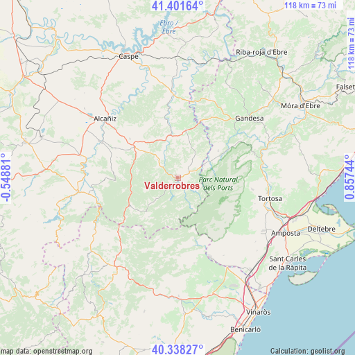
Valderrobres GPS coordinates[2]
40° 52' 19.524" North, 0° 9' 15.516" East
| Map corner | latitude | longitude |
|---|---|---|
| Upper-left | 41.40164°, | -0.54881° |
| Center: | 40.87209°, | 0.15431° |
| Lower-right: | 40.33827°, | 0.85744° |
| Map W x H: | 118.2×118.2 km | = 73.4×73.4mi |
| max Lat: | 43.74134° ⇑54.5% North |
| Valderrobres: | 40.87209° |
| min Lat: | ⇓45.5% South 27.64134° |
| min Long | Valderrobres | max Long |
| -18.00367° | 0.15431° | 4.2899° |
| W 87.7%⇐ | ⇒12.3% E |
Elevation
Elevation of Valderrobres is 498 m = 1634 ft, and this is 100 m = 328 ft below average elevation for this country.
| Max E: |
1682 m = 5518 ft | 62.1% |
| Avg. | 598 m = 1962 ft | |
| Valderrobres | 498 m = 1634 ft | |
Min E: |
0 m = 0 ft | 37.9% |
See also: Spain elevation on elevation.city.
Geographical zone
Valderrobres is located in North temperate zone (between Tropic of Cancer and the Arctic Circle). Distance of this Northern Tropic circle is 1938.6 km =1204.6 mi to South.| Distance of | km | miles | from Valderrobres |
|---|---|---|---|
| North Pole | 5462.5 | 3394.2 | to North |
| Arctic Circle | 2856.6 | 1775 | to North |
| Tropic Cancer | 1938.6 | 1204.6 | to South |
| Equator | 4544.6 | 2823.9 | to South |


Nearby cities:
15 places around Valderrobres: (largest is in red/bold)
• Arenys de Lledó / Arens de Lledó
16.6 km =10.3 mi,  36°
36°
• Arnes
9.9 km =6.2 mi,  64°
64°
• Beseit / Beceite
5.1 km =3.2 mi,  151°
151°
• Calaceite
16.3 km =10.1 mi,  10°
10°
• Cretas
7.9 km =4.9 mi, 37°
• Fuentespalda
10.4 km =6.5 mi,  225°
225°
• Fórnoles
13.5 km =8.4 mi,  280°
280°
• Horta de Sant Joan
16.2 km =10.1 mi, 57°
• Lledó
13.9 km =8.6 mi,  48°
48°
• Monroyo
18.5 km =11.5 mi,  239°
239°
• Peñarroya de Tastavíns
16.1 km =10 mi,  216°
216°
• Ráfales
12 km =7.5 mi,  251°
251°
• Torre del Compte
8.1 km =5 mi,  332°
332°
• Valdeltormo
14.1 km =8.8 mi,  335°
335°
• Valjunquera
14 km =8.7 mi,  309°
309°
Sources, notices
• [Note1] Compared only with cities in Spain existing in our database
• [Src1] Map data: © OpenStreetMap contributors (CC-BY-SA)
• [Src2] Other city data from geonames.org with taken over terms of usage.
• [Src3] Geographical zone / Annual Mean Temperature by Robert A. Rohde @ Wikipedia
