Mazaleón geodata
Mazaleón (Aragon) is a seat of a third-order administrative division; located in Spain in Europe/Madrid (GMT+2) time zone. With population of 577 people, there are 3666 cities with bigger population in this country. Compared to other cities in Spain, 50.4% of cities are located further ↑North; 87.5% of cities are located further ←West and 71.2% of cities have higher elevation than Mazaleón. Note1


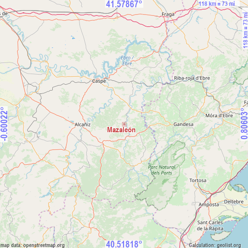
Mazaleón GPS coordinates[2]
41° 3' 2.016" North, 0° 6' 10.44" East
| Map corner | latitude | longitude |
|---|---|---|
| Upper-left | 41.57867°, | -0.60022° |
| Center: | 41.05056°, | 0.1029° |
| Lower-right: | 40.51818°, | 0.80603° |
| Map W x H: | 117.9×117.9 km | = 73.3×73.3mi |
| max Lat: | 43.74134° ⇑50.4% North |
| Mazaleón: | 41.05056° |
| min Lat: | ⇓49.6% South 27.64134° |
| min Long | Mazaleón | max Long |
| -18.00367° | 0.1029° | 4.2899° |
| W 87.5%⇐ | ⇒12.5% E |
Elevation
Elevation of Mazaleón is 363 m = 1191 ft, and this is 235 m = 771 ft below average elevation for this country.
| Max E: |
1682 m = 5518 ft | 71.2% |
| Avg. | 598 m = 1962 ft | |
| Mazaleón | 363 m = 1191 ft | |
Min E: |
0 m = 0 ft | 28.8% |
See also: Spain elevation on elevation.city.
Geographical zone
Mazaleón is located in North temperate zone (between Tropic of Cancer and the Arctic Circle). Distance of this Northern Tropic circle is 1958.5 km =1217 mi to South.| Distance of | km | miles | from Mazaleón |
|---|---|---|---|
| North Pole | 5442.7 | 3381.9 | to North |
| Arctic Circle | 2836.8 | 1762.7 | to North |
| Tropic Cancer | 1958.5 | 1217 | to South |
| Equator | 4564.4 | 2836.2 | to South |


Nearby cities:
15 places around Mazaleón: (largest is in red/bold)
• Alcañiz
19.8 km =12.3 mi,  269°
269°
• Arenys de Lledó / Arens de Lledó
15.5 km =9.6 mi,  114°
114°
• Batea
18.1 km =11.2 mi,  74°
74°
• Calaceite
8.1 km =5 mi,  117°
117°
• Caseres
12.5 km =7.8 mi,  98°
98°
• Cretas
16.4 km =10.2 mi,  146°
146°
• Fabara
15.2 km =9.4 mi,  21°
21°
• Fórnoles
19.6 km =12.2 mi,  207°
207°
• Lledó
18.1 km =11.2 mi,  125°
125°
• Maella
8.6 km =5.3 mi, 20°
• Torre del Compte
12.7 km =7.9 mi,  177°
177°
• Torrecilla de Alcañiz
19.1 km =11.9 mi,  238°
238°
• Valdealgorfa
13.3 km =8.3 mi, 239°
• Valdeltormo
7.2 km =4.5 mi,  193°
193°
• Valjunquera
12.7 km =7.9 mi, 210°
Sources, notices
• [Note1] Compared only with cities in Spain existing in our database
• [Src1] Map data: © OpenStreetMap contributors (CC-BY-SA)
• [Src2] Other city data from geonames.org with taken over terms of usage.
• [Src3] Geographical zone / Annual Mean Temperature by Robert A. Rohde @ Wikipedia
