Batea geodata
Batea (Catalonia) is a seat of a third-order administrative division; located in Spain in Europe/Madrid (GMT+2) time zone. With population of 2,086 people, there are 2107 cities with bigger population in this country. Compared to other cities in Spain, 50.8% of cities are located further ↓South; 88.3% of cities are located further ←West and 71.1% of cities have higher elevation than Batea. Note1


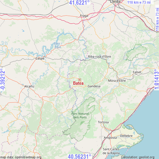
Batea GPS coordinates[2]
41° 5' 39.624" North, 0° 18' 39.6" East
| Map corner | latitude | longitude |
|---|---|---|
| Upper-left | 41.6221°, | -0.39212° |
| Center: | 41.09434°, | 0.311° |
| Lower-right: | 40.56231°, | 1.01413° |
| Map W x H: | 117.8×117.8 km | = 73.2×73.2mi |
| max Lat: | 43.74134° ⇑49.2% North |
| Batea: | 41.09434° |
| min Lat: | ⇓50.8% South 27.64134° |
| min Long | Batea | max Long |
| -18.00367° | 0.311° | 4.2899° |
| W 88.3%⇐ | ⇒11.7% E |
Elevation
Elevation of Batea is 365 m = 1198 ft, and this is 233 m = 764 ft below average elevation for this country.
| Max E: |
1682 m = 5518 ft | 71.1% |
| Avg. | 598 m = 1962 ft | |
| Batea | 365 m = 1198 ft | |
Min E: |
0 m = 0 ft | 28.9% |
See also: Spain elevation on elevation.city.
Geographical zone
Batea is located in North temperate zone (between Tropic of Cancer and the Arctic Circle). Distance of this Northern Tropic circle is 1963.3 km =1219.9 mi to South.| Distance of | km | miles | from Batea |
|---|---|---|---|
| North Pole | 5437.8 | 3378.9 | to North |
| Arctic Circle | 2831.9 | 1759.7 | to North |
| Tropic Cancer | 1963.3 | 1219.9 | to South |
| Equator | 4569.3 | 2839.2 | to South |


Nearby cities:
15 places around Batea: (largest is in red/bold)
• Arenys de Lledó / Arens de Lledó
11.8 km =7.3 mi,  196°
196°
• Bot
11.3 km =7 mi,  147°
147°
• Calaceite
13.4 km =8.3 mi,  229°
229°
• Caseres
8.5 km =5.3 mi,  217°
217°
• Fabara
15.1 km =9.4 mi,  307°
307°
• Fayón
16.1 km =10 mi,  6°
6°
• Gandesa
11.6 km =7.2 mi,  112°
112°
• Horta de Sant Joan
16.1 km =10 mi,  178°
178°
• Lledó
15.7 km =9.8 mi,  190°
190°
• Maella
14.7 km =9.1 mi,  282°
282°
• Mazaleón
18.1 km =11.2 mi,  254°
254°
• Nonaspe
13.8 km =8.6 mi,  337°
337°
• Vilalba dels Arcs
9.2 km =5.7 mi,  74°
74°
• la Fatarella
16.5 km =10.3 mi,  60°
60°
• la Pobla de Massaluca
10.4 km =6.5 mi,  18°
18°
Sources, notices
• [Note1] Compared only with cities in Spain existing in our database
• [Src1] Map data: © OpenStreetMap contributors (CC-BY-SA)
• [Src2] Other city data from geonames.org with taken over terms of usage.
• [Src3] Geographical zone / Annual Mean Temperature by Robert A. Rohde @ Wikipedia
