Leiva geodata
Leiva (La Rioja) is a seat of a third-order administrative division; located in Spain in Europe/Madrid (GMT+2) time zone. With population of 273 people, there are 4613 cities with bigger population in this country. Compared to other cities in Spain, 87.2% of cities are located further ↓South; 53.6% of cities are located further ←West and 55.4% of cities have higher elevation than Leiva. Note1


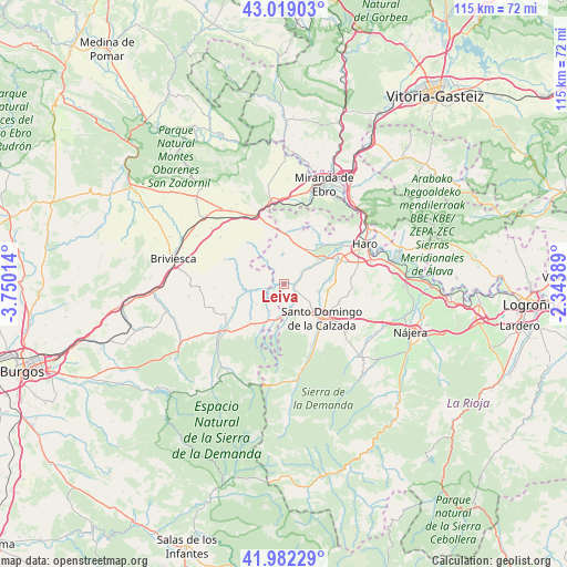
Leiva GPS coordinates[2]
42° 30' 10.116" North, 3° 2' 49.236" West
| Map corner | latitude | longitude |
|---|---|---|
| Upper-left | 43.01903°, | -3.75014° |
| Center: | 42.50281°, | -3.04701° |
| Lower-right: | 41.98229°, | -2.34389° |
| Map W x H: | 115.3×115.3 km | = 71.6×71.6mi |
| max Lat: | 43.74134° ⇑12.8% North |
| Leiva: | 42.50281° |
| min Lat: | ⇓87.2% South 27.64134° |
| min Long | Leiva | max Long |
| -18.00367° | -3.04701° | 4.2899° |
| W 53.6%⇐ | ⇒46.4% E |
Elevation
Elevation of Leiva is 590 m = 1936 ft, and this is 8 m = 26 ft below average elevation for this country.
| Max E: |
1682 m = 5518 ft | 55.4% |
| Avg. | 598 m = 1962 ft | |
| Leiva | 590 m = 1936 ft | |
Min E: |
0 m = 0 ft | 44.6% |
See also: Spain elevation on elevation.city.
Geographical zone
Leiva is located in North temperate zone (between Tropic of Cancer and the Arctic Circle). Distance of this Northern Tropic circle is 2120 km =1317.3 mi to South.| Distance of | km | miles | from Leiva |
|---|---|---|---|
| North Pole | 5281.2 | 3281.6 | to North |
| Arctic Circle | 2675.3 | 1662.4 | to North |
| Tropic Cancer | 2120 | 1317.3 | to South |
| Equator | 4725.9 | 2936.5 | to South |


Nearby cities:
15 places around Leiva: (largest is in red/bold)
• Baños de Rioja
8.3 km =5.2 mi,  82°
82°
• Castildelgado
7.9 km =4.9 mi,  202°
202°
• Cerezo de Río Tirón
7.4 km =4.6 mi,  260°
260°
• Cuzcurrita de Río Tirón
8 km =5 mi,  57°
57°
• Grañón
6.1 km =3.8 mi,  164°
164°
• Herramélluri
2.3 km =1.4 mi,  89°
89°
• Ibrillos
6.1 km =3.8 mi,  208°
208°
• Ochánduri
4.3 km =2.7 mi,  54°
54°
• Redecilla del Camino
7.4 km =4.6 mi,  191°
191°
• Redecilla del Campo
6.9 km =4.3 mi,  234°
234°
• San Millán de Yécora
6.4 km =4 mi,  320°
320°
• Tormantos
2.4 km =1.5 mi,  247°
247°
• Treviana
6.3 km =3.9 mi,  357°
357°
• Villalobar de Rioja
6.9 km =4.3 mi,  100°
100°
• Villarta-Quintana
8.1 km =5 mi,  180°
180°
Sources, notices
• [Note1] Compared only with cities in Spain existing in our database
• [Src1] Map data: © OpenStreetMap contributors (CC-BY-SA)
• [Src2] Other city data from geonames.org with taken over terms of usage.
• [Src3] Geographical zone / Annual Mean Temperature by Robert A. Rohde @ Wikipedia
