Treviana geodata
Treviana (La Rioja) is a seat of a third-order administrative division; located in Spain in Europe/Madrid (GMT+2) time zone. With population of 228 people, there are 4870 cities with bigger population in this country. Compared to other cities in Spain, 88.4% of cities are located further ↓South; 53.6% of cities are located further ←West and 56.1% of cities have higher elevation than Treviana. Note1


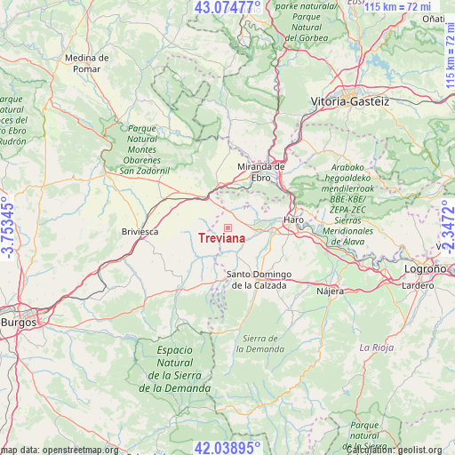
Treviana GPS coordinates[2]
42° 33' 32.436" North, 3° 3' 1.152" West
| Map corner | latitude | longitude |
|---|---|---|
| Upper-left | 43.07477°, | -3.75345° |
| Center: | 42.55901°, | -3.05032° |
| Lower-right: | 42.03895°, | -2.3472° |
| Map W x H: | 115.2×115.2 km | = 71.6×71.6mi |
| max Lat: | 43.74134° ⇑11.6% North |
| Treviana: | 42.55901° |
| min Lat: | ⇓88.4% South 27.64134° |
| min Long | Treviana | max Long |
| -18.00367° | -3.05032° | 4.2899° |
| W 53.6%⇐ | ⇒46.4% E |
Elevation
Elevation of Treviana is 581 m = 1906 ft, and this is 17 m = 56 ft below average elevation for this country.
| Max E: |
1682 m = 5518 ft | 56.1% |
| Avg. | 598 m = 1962 ft | |
| Treviana | 581 m = 1906 ft | |
Min E: |
0 m = 0 ft | 43.9% |
See also: Spain elevation on elevation.city.
Geographical zone
Treviana is located in North temperate zone (between Tropic of Cancer and the Arctic Circle). Distance of this Northern Tropic circle is 2126.2 km =1321.2 mi to South.| Distance of | km | miles | from Treviana |
|---|---|---|---|
| North Pole | 5274.9 | 3277.7 | to North |
| Arctic Circle | 2669.1 | 1658.5 | to North |
| Tropic Cancer | 2126.2 | 1321.2 | to South |
| Equator | 4732.1 | 2940.4 | to South |


Nearby cities:
15 places around Treviana: (largest is in red/bold)
• Altable
5.3 km =3.3 mi,  335°
335°
• Baños de Rioja
10 km =6.2 mi,  121°
121°
• Cellorigo
8.6 km =5.3 mi,  28°
28°
• Cuzcurrita de Río Tirón
7.3 km =4.5 mi,  105°
105°
• Foncea
6.3 km =3.9 mi,  8°
8°
• Fonzaleche
4 km =2.5 mi,  51°
51°
• Herramélluri
6.7 km =4.2 mi,  157°
157°
• Leiva
6.3 km =3.9 mi,  177°
177°
• Ochánduri
5.3 km =3.3 mi,  134°
134°
• Pancorbo
9.8 km =6.1 mi,  328°
328°
• Sajazarra
8 km =5 mi,  65°
65°
• San Millán de Yécora
4 km =2.5 mi,  250°
250°
• Tirgo
8.4 km =5.2 mi,  100°
100°
• Tormantos
7.5 km =4.7 mi,  195°
195°
• Valluércanes
6 km =3.7 mi,  284°
284°
Sources, notices
• [Note1] Compared only with cities in Spain existing in our database
• [Src1] Map data: © OpenStreetMap contributors (CC-BY-SA)
• [Src2] Other city data from geonames.org with taken over terms of usage.
• [Src3] Geographical zone / Annual Mean Temperature by Robert A. Rohde @ Wikipedia
