Castildelgado geodata
Castildelgado (Castille and León) is a seat of a third-order administrative division; located in Spain in Europe/Madrid (GMT+2) time zone. With population of 65 people, there are 6290 cities with bigger population in this country. Compared to other cities in Spain, 85.9% of cities are located further ↓South; 53% of cities are located further ←West and 63.6% of cities have lower elevation than Castildelgado. Note1
Administrative division(s):
- Level 1: Castille and León
- Level 2: Provincia de Burgos
- Level 3: Castildelgado


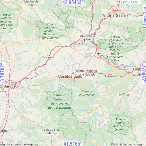
Castildelgado GPS coordinates[2]
42° 26' 15.216" North, 3° 5' 2.004" West
| Map corner | latitude | longitude |
|---|---|---|
| Upper-left | 42.95433°, | -3.78702° |
| Center: | 42.43756°, | -3.08389° |
| Lower-right: | 41.9165°, | -2.38077° |
| Map W x H: | 115.4×115.4 km | = 71.7×71.7mi |
| max Lat: | 43.74134° ⇑14.1% North |
| Castildelgado: | 42.43756° |
| min Lat: | ⇓85.9% South 27.64134° |
| min Long | Castildelgado | max Long |
| -18.00367° | -3.08389° | 4.2899° |
| W 53%⇐ | ⇒47% E |
Elevation
Elevation of Castildelgado is 768 m = 2520 ft, and this is 170 m = 558 ft above average elevation for this country.
| Max E: |
1682 m = 5518 ft | 36.4% |
| Castildelgado | 768 m 2520 ft | |
| Avg. | 598 m = 1962 ft | |
Min E: |
0 m = 0 ft | 63.6% |
See also: Spain elevation on elevation.city.
Geographical zone
Castildelgado is located in North temperate zone (between Tropic of Cancer and the Arctic Circle). Distance of this Northern Tropic circle is 2112.7 km =1312.8 mi to South.| Distance of | km | miles | from Castildelgado |
|---|---|---|---|
| North Pole | 5288.4 | 3286.1 | to North |
| Arctic Circle | 2682.6 | 1666.9 | to North |
| Tropic Cancer | 2112.7 | 1312.8 | to South |
| Equator | 4718.6 | 2932 | to South |


Nearby cities:
15 places around Castildelgado: (largest is in red/bold)
• Bascuñana
1.3 km =0.8 mi,  174°
174°
• Belorado
9 km =5.6 mi,  257°
257°
• Cerezo de Río Tirón
7.4 km =4.6 mi,  324°
324°
• Corporales
7.3 km =4.5 mi,  94°
94°
• Fresneña
4.9 km =3 mi,  237°
237°
• Grañón
4.8 km =3 mi,  73°
73°
• Herramélluri
9 km =5.6 mi,  35°
35°
• Ibrillos
1.9 km =1.2 mi,  3°
3°
• Leiva
7.9 km =4.9 mi,  22°
22°
• Redecilla del Camino
1.5 km =0.9 mi, 87°
• Redecilla del Campo
4.1 km =2.5 mi, 321°
• Santo Domingo de la Calzada
10.7 km =6.6 mi, 88°
• Tormantos
6.4 km =4 mi,  6°
6°
• Villarta-Quintana
3 km =1.9 mi,  106°
106°
• Viloria de Rioja
1.9 km =1.2 mi,  226°
226°
Sources, notices
• [Note1] Compared only with cities in Spain existing in our database
• [Src1] Map data: © OpenStreetMap contributors (CC-BY-SA)
• [Src2] Other city data from geonames.org with taken over terms of usage.
• [Src3] Geographical zone / Annual Mean Temperature by Robert A. Rohde @ Wikipedia
