Grañón geodata
Grañón (La Rioja) is a seat of a third-order administrative division; located in Spain in Europe/Madrid (GMT+2) time zone. With population of 360 people, there are 4277 cities with bigger population in this country. Compared to other cities in Spain, 86.1% of cities are located further ↓South; 53.9% of cities are located further ←West and 58.1% of cities have lower elevation than Grañón. Note1


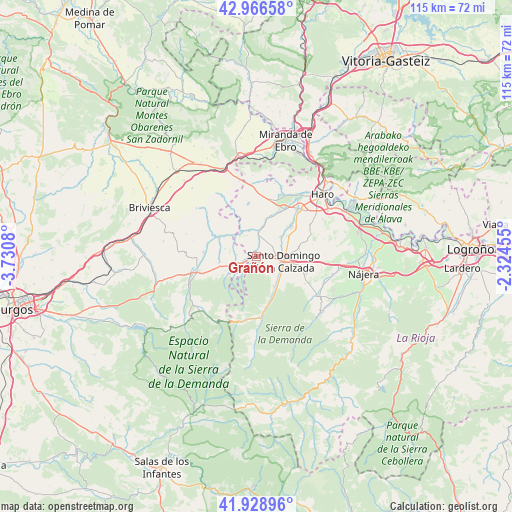
Grañón GPS coordinates[2]
42° 26' 59.712" North, 3° 1' 39.612" West
| Map corner | latitude | longitude |
|---|---|---|
| Upper-left | 42.96658°, | -3.7308° |
| Center: | 42.44992°, | -3.02767° |
| Lower-right: | 41.92896°, | -2.32455° |
| Map W x H: | 115.4×115.4 km | = 71.7×71.7mi |
| max Lat: | 43.74134° ⇑13.9% North |
| Grañón: | 42.44992° |
| min Lat: | ⇓86.1% South 27.64134° |
| min Long | Grañón | max Long |
| -18.00367° | -3.02767° | 4.2899° |
| W 53.9%⇐ | ⇒46.1% E |
Elevation
Elevation of Grañón is 730 m = 2395 ft, and this is 132 m = 433 ft above average elevation for this country.
| Max E: |
1682 m = 5518 ft | 41.9% |
| Grañón | 730 m 2395 ft | |
| Avg. | 598 m = 1962 ft | |
Min E: |
0 m = 0 ft | 58.1% |
See also: Spain elevation on elevation.city.
Geographical zone
Grañón is located in North temperate zone (between Tropic of Cancer and the Arctic Circle). Distance of this Northern Tropic circle is 2114.1 km =1313.6 mi to South.| Distance of | km | miles | from Grañón |
|---|---|---|---|
| North Pole | 5287.1 | 3285.3 | to North |
| Arctic Circle | 2681.2 | 1666 | to North |
| Tropic Cancer | 2114.1 | 1313.6 | to South |
| Equator | 4720 | 2932.9 | to South |


Nearby cities:
15 places around Grañón: (largest is in red/bold)
• Bascuñana
5.2 km =3.2 mi,  238°
238°
• Baños de Rioja
9.6 km =6 mi,  43°
43°
• Castildelgado
4.8 km =3 mi,  253°
253°
• Corporales
3.3 km =2.1 mi,  126°
126°
• Herramélluri
5.9 km =3.7 mi,  6°
6°
• Ibrillos
4.5 km =2.8 mi,  276°
276°
• Leiva
6.1 km =3.8 mi,  344°
344°
• Ochánduri
8.6 km =5.3 mi, 12°
• Redecilla del Camino
3.4 km =2.1 mi, 246°
• Redecilla del Campo
7.4 km =4.6 mi, 284°
• Santo Domingo de la Calzada
6.2 km =3.9 mi,  100°
100°
• Tormantos
6.3 km =3.9 mi,  322°
322°
• Villalobar de Rioja
7 km =4.3 mi,  48°
48°
• Villarta-Quintana
2.8 km =1.7 mi,  217°
217°
• Viloria de Rioja
6.5 km =4 mi, 246°
Sources, notices
• [Note1] Compared only with cities in Spain existing in our database
• [Src1] Map data: © OpenStreetMap contributors (CC-BY-SA)
• [Src2] Other city data from geonames.org with taken over terms of usage.
• [Src3] Geographical zone / Annual Mean Temperature by Robert A. Rohde @ Wikipedia
