Lantziego / Lanciego geodata
Lantziego / Lanciego (Basque Country) is a populated place; located in Spain in Europe/Madrid (GMT+2) time zone. With population of 640 people, there are 3521 cities with bigger population in this country. Compared to other cities in Spain, 88.5% of cities are located further ↓South; 60.8% of cities are located further ←West and 58.3% of cities have higher elevation than Lantziego / Lanciego. Note1
Administrative division(s):
- Level 1: Basque Country
- Level 2: Araba / Álava
- Level 3: Lantziego / Lanciego


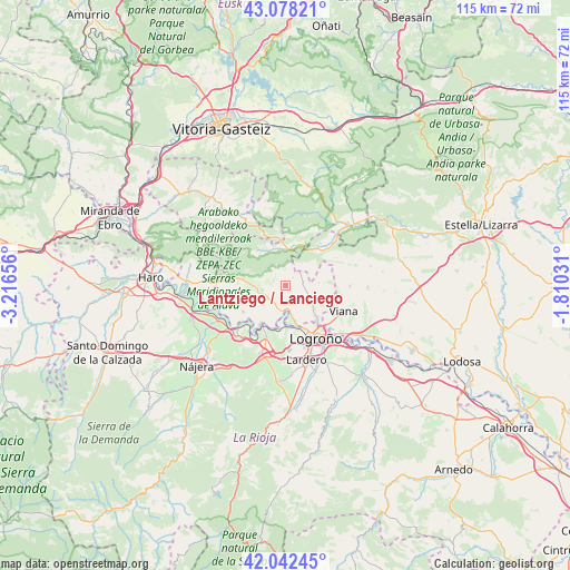
Lantziego / Lanciego GPS coordinates[2]
42° 33' 44.928" North, 2° 30' 48.348" West
| Map corner | latitude | longitude |
|---|---|---|
| Upper-left | 43.07821°, | -3.21656° |
| Center: | 42.56248°, | -2.51343° |
| Lower-right: | 42.04245°, | -1.81031° |
| Map W x H: | 115.2×115.2 km | = 71.6×71.6mi |
| max Lat: | 43.74134° ⇑11.5% North |
| Lantziego / Lanciego: | 42.56248° |
| min Lat: | ⇓88.5% South 27.64134° |
| min Long | Lantziego / Lan | max Long |
| -18.00367° | -2.51343° | 4.2899° |
| W 60.8%⇐ | ⇒39.2% E |
Elevation
Elevation of Lantziego / Lanciego is 549 m = 1801 ft, and this is 49 m = 161 ft below average elevation for this country.
| Max E: |
1682 m = 5518 ft | 58.3% |
| Avg. | 598 m = 1962 ft | |
| Lantziego / Lanciego | 549 m = 1801 ft | |
Min E: |
0 m = 0 ft | 41.7% |
See also: Spain elevation on elevation.city.
Geographical zone
Lantziego / Lanciego is located in North temperate zone (between Tropic of Cancer and the Arctic Circle). Distance of this Northern Tropic circle is 2126.6 km =1321.4 mi to South.| Distance of | km | miles | from Lantziego / Lanciego |
|---|---|---|---|
| North Pole | 5274.6 | 3277.5 | to North |
| Arctic Circle | 2668.7 | 1658.3 | to North |
| Tropic Cancer | 2126.6 | 1321.4 | to South |
| Equator | 4732.5 | 2940.6 | to South |


Nearby cities:
15 places around Lantziego / Lanciego: (largest is in red/bold)
• Aguilar de Codés
11.5 km =7.1 mi,  61°
61°
• Bernedo
7.2 km =4.5 mi,  10°
10°
• Cabredo
11.2 km =7 mi,  48°
48°
• Elciego
10.1 km =6.3 mi,  238°
238°
• Fuenmayor
11.3 km =7 mi,  200°
200°
• Lagrán
9.1 km =5.7 mi,  320°
320°
• Laguardia
5.9 km =3.7 mi,  261°
261°
• Lapoblación
6.4 km =4 mi,  42°
42°
• Lapuebla de Labarca
9 km =5.6 mi,  213°
213°
• Leza
9.8 km =6.1 mi,  271°
271°
• Logroño
11.9 km =7.4 mi,  153°
153°
• Marañón
9.6 km =6 mi, 39°
• Moreda Araba / Moreda de Álava
9.5 km =5.9 mi,  115°
115°
• Navaridas
9.4 km =5.8 mi, 258°
• Oion / Oyón
8.9 km =5.5 mi,  134°
134°
Sources, notices
• [Note1] Compared only with cities in Spain existing in our database
• [Src1] Map data: © OpenStreetMap contributors (CC-BY-SA)
• [Src2] Other city data from geonames.org with taken over terms of usage.
• [Src3] Geographical zone / Annual Mean Temperature by Robert A. Rohde @ Wikipedia
