Fuenmayor geodata
Fuenmayor (La Rioja) is a seat of a third-order administrative division; located in Spain in Europe/Madrid (GMT+2) time zone. With population of 2,827 people, there are 1778 cities with bigger population in this country. Compared to other cities in Spain, 86.5% of cities are located further ↓South; 60.3% of cities are located further ←West and 66.9% of cities have higher elevation than Fuenmayor. Note1


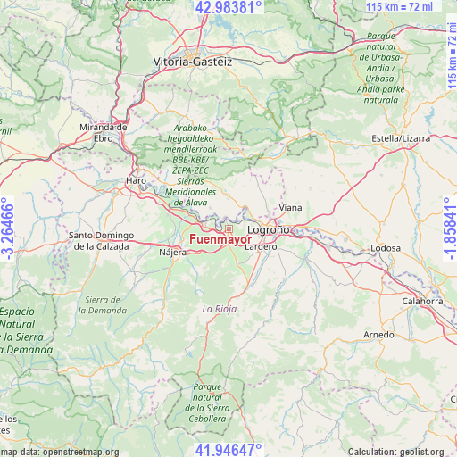
Fuenmayor GPS coordinates[2]
42° 28' 2.244" North, 2° 33' 41.508" West
| Map corner | latitude | longitude |
|---|---|---|
| Upper-left | 42.98381°, | -3.26466° |
| Center: | 42.46729°, | -2.56153° |
| Lower-right: | 41.94647°, | -1.85841° |
| Map W x H: | 115.3×115.3 km | = 71.6×71.6mi |
| max Lat: | 43.74134° ⇑13.5% North |
| Fuenmayor: | 42.46729° |
| min Lat: | ⇓86.5% South 27.64134° |
| min Long | Fuenmayor | max Long |
| -18.00367° | -2.56153° | 4.2899° |
| W 60.3%⇐ | ⇒39.7% E |
Elevation
Elevation of Fuenmayor is 435 m = 1427 ft, and this is 163 m = 535 ft below average elevation for this country.
| Max E: |
1682 m = 5518 ft | 66.9% |
| Avg. | 598 m = 1962 ft | |
| Fuenmayor | 435 m = 1427 ft | |
Min E: |
0 m = 0 ft | 33.1% |
See also: Spain elevation on elevation.city.
Geographical zone
Fuenmayor is located in North temperate zone (between Tropic of Cancer and the Arctic Circle). Distance of this Northern Tropic circle is 2116 km =1314.8 mi to South.| Distance of | km | miles | from Fuenmayor |
|---|---|---|---|
| North Pole | 5285.1 | 3284 | to North |
| Arctic Circle | 2679.3 | 1664.8 | to North |
| Tropic Cancer | 2116 | 1314.8 | to South |
| Equator | 4721.9 | 2934.1 | to South |


Nearby cities:
15 places around Fuenmayor: (largest is in red/bold)
• Cenicero
7 km =4.3 mi,  282°
282°
• Daroca de Rioja
10.8 km =6.7 mi,  188°
188°
• Elciego
7.2 km =4.5 mi,  318°
318°
• Entrena
9.2 km =5.7 mi,  164°
164°
• Hornos de Moncalvillo
8.6 km =5.3 mi, 193°
• Laguardia
9.9 km =6.2 mi,  348°
348°
• Lapuebla de Labarca
3.2 km =2 mi,  342°
342°
• Lardero
9.4 km =5.8 mi,  118°
118°
• Logroño
9.1 km =5.7 mi,  90°
90°
• Medrano
9.3 km =5.8 mi,  176°
176°
• Navaridas
10.2 km =6.3 mi,  328°
328°
• Navarrete
4.1 km =2.5 mi, 183°
• Sojuela
10.9 km =6.8 mi,  172°
172°
• Torremontalbo
10.6 km =6.6 mi,  290°
290°
• Ventosa
8.7 km =5.4 mi,  217°
217°
Sources, notices
• [Note1] Compared only with cities in Spain existing in our database
• [Src1] Map data: © OpenStreetMap contributors (CC-BY-SA)
• [Src2] Other city data from geonames.org with taken over terms of usage.
• [Src3] Geographical zone / Annual Mean Temperature by Robert A. Rohde @ Wikipedia
