Moreda Araba / Moreda de Álava geodata
Moreda Araba / Moreda de Álava (Basque Country) is a seat of a third-order administrative division; located in Spain in Europe/Madrid (GMT+2) time zone. With population of 275 people, there are 4603 cities with bigger population in this country. Compared to other cities in Spain, 87.9% of cities are located further ↓South; 62.2% of cities are located further ←West and 64.9% of cities have higher elevation than Moreda Araba / Moreda de Álava. Note1
Administrative division(s):
- Level 1: Basque Country
- Level 2: Araba / Álava
- Level 3: Moreda Araba / Moreda de Álava
Current local time in Moreda Araba / Moreda de Álava:
10:42 PM, ThursdayDifference from your time zone: hours


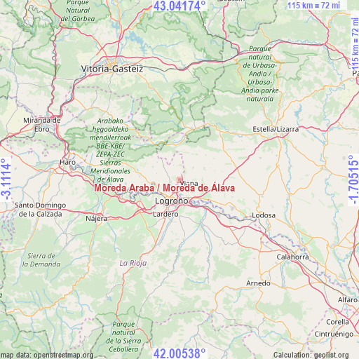
Moreda Araba / Moreda de Álava GPS coordinates[2]
42° 31' 32.556" North, 2° 24' 29.808" West
| Map corner | latitude | longitude |
|---|---|---|
| Upper-left | 43.04174°, | -3.1114° |
| Center: | 42.52571°, | -2.40828° |
| Lower-right: | 42.00538°, | -1.70515° |
| Map W x H: | 115.2×115.2 km | = 71.6×71.6mi |
| max Lat: | 43.74134° ⇑12.1% North |
| Moreda Araba / Moreda de Álava: | 42.52571° |
| min Lat: | ⇓87.9% South 27.64134° |
| min Long | Moreda Araba / | max Long |
| -18.00367° | -2.40828° | 4.2899° |
| W 62.2%⇐ | ⇒37.8% E |
Elevation
Elevation of Moreda Araba / Moreda de Álava is 462 m = 1516 ft, and this is 136 m = 446 ft below average elevation for this country.
| Max E: |
1682 m = 5518 ft | 64.9% |
| Avg. | 598 m = 1962 ft | |
| Moreda Araba / Moreda de Álava | 462 m = 1516 ft | |
Min E: |
0 m = 0 ft | 35.1% |
See also: Spain elevation on elevation.city.
Geographical zone
Moreda Araba / Moreda de Álava is located in North temperate zone (between Tropic of Cancer and the Arctic Circle). Distance of this Northern Tropic circle is 2122.5 km =1318.9 mi to South.| Distance of | km | miles | from Moreda Araba / Moreda de Álava |
|---|---|---|---|
| North Pole | 5278.6 | 3280 | to North |
| Arctic Circle | 2672.8 | 1660.8 | to North |
| Tropic Cancer | 2122.5 | 1318.9 | to South |
| Equator | 4728.4 | 2938.1 | to South |


Nearby cities:
15 places around Moreda Araba / Moreda de Álava: (largest is in red/bold)
• Aguilar de Codés
9.8 km =6.1 mi,  8°
8°
• Aras
5.9 km =3.7 mi,  46°
46°
• Armañanzas
10.8 km =6.7 mi,  69°
69°
• Azuelo
10.4 km =6.5 mi,  27°
27°
• Bargota
8.9 km =5.5 mi,  64°
64°
• Cabredo
11.6 km =7.2 mi,  358°
358°
• Espronceda
11.6 km =7.2 mi, 46°
• Lantziego / Lanciego
9.5 km =5.9 mi,  295°
295°
• Lapoblación
9.8 km =6.1 mi,  334°
334°
• Lardero
11.8 km =7.3 mi,  201°
201°
• Logroño
7.4 km =4.6 mi,  207°
207°
• Oion / Oyón
3.2 km =2 mi,  226°
226°
• Torres del Río
11.5 km =7.1 mi,  75°
75°
• Viana
3.2 km =2 mi,  110°
110°
• Villamediana de Iregua
11.1 km =6.9 mi,  184°
184°
Sources, notices
• [Note1] Compared only with cities in Spain existing in our database
• [Src1] Map data: © OpenStreetMap contributors (CC-BY-SA)
• [Src2] Other city data from geonames.org with taken over terms of usage.
• [Src3] Geographical zone / Annual Mean Temperature by Robert A. Rohde @ Wikipedia
