Cabredo geodata
Cabredo (Navarre) is a seat of a third-order administrative division; located in Spain in Europe/Madrid (GMT+2) time zone. With population of 106 people, there are 5853 cities with bigger population in this country. Compared to other cities in Spain, 90.3% of cities are located further ↓South; 62.1% of cities are located further ←West and 50.1% of cities have higher elevation than Cabredo. Note1


Cabredo GPS coordinates[2]
42° 37' 46.776" North, 2° 24' 40.788" West
| Map corner | latitude | longitude |
|---|---|---|
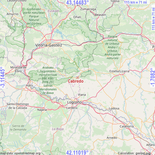
| Upper-left | 43.14483°, | -3.11445° |
| Center: | 42.62966°, | -2.41133° |
| Lower-right: | 42.11019°, | -1.7082° |
| Map W x H: | 115×115 km | = 71.5×71.5mi |
| max Lat: | 43.74134° ⇑9.7% North |
| Cabredo: | 42.62966° |
| min Lat: | ⇓90.3% South 27.64134° |
| min Long | Cabredo | max Long |
| -18.00367° | -2.41133° | 4.2899° |
| W 62.1%⇐ | ⇒37.9% E |
Elevation
Elevation of Cabredo is 656 m = 2152 ft, and this is 58 m = 190 ft above average elevation for this country.
| Max E: |
1682 m = 5518 ft | 50.1% |
| Cabredo | 656 m 2152 ft | |
| Avg. | 598 m = 1962 ft | |
Min E: |
0 m = 0 ft | 49.9% |
See also: Spain elevation on elevation.city.
Geographical zone
Cabredo is located in North temperate zone (between Tropic of Cancer and the Arctic Circle). Distance of this Northern Tropic circle is 2134.1 km =1326.1 mi to South.| Distance of | km | miles | from Cabredo |
|---|---|---|---|
| North Pole | 5267.1 | 3272.8 | to North |
| Arctic Circle | 2661.2 | 1653.6 | to North |
| Tropic Cancer | 2134.1 | 1326.1 | to South |
| Equator | 4740 | 2945.3 | to South |


Nearby cities:
15 places around Cabredo: (largest is in red/bold)
• Aguilar de Codés
2.6 km =1.6 mi,  137°
137°
• Aras
8.8 km =5.5 mi,  149°
149°
• Azuelo
5.6 km =3.5 mi,  115°
115°
• Bargota
11.3 km =7 mi,  133°
133°
• Bernedo
7.1 km =4.4 mi,  267°
267°
• Desojo
12.1 km =7.5 mi,  112°
112°
• Espronceda
9.4 km =5.8 mi, 112°
• Genevilla
2.4 km =1.5 mi,  44°
44°
• Lantziego / Lanciego
11.2 km =7 mi,  228°
228°
• Lapoblación
4.9 km =3 mi,  235°
235°
• Marañón
2.3 km =1.4 mi, 269°
• Mirafuentes
10.8 km =6.7 mi,  93°
93°
• Moreda Araba / Moreda de Álava
11.6 km =7.2 mi,  178°
178°
• Nazar
10.8 km =6.7 mi, 85°
• Zúñiga
11.5 km =7.1 mi,  52°
52°
Sources, notices
• [Note1] Compared only with cities in Spain existing in our database
• [Src1] Map data: © OpenStreetMap contributors (CC-BY-SA)
• [Src2] Other city data from geonames.org with taken over terms of usage.
• [Src3] Geographical zone / Annual Mean Temperature by Robert A. Rohde @ Wikipedia
