Lagunilla geodata
Lagunilla (Castille and León) is a seat of a third-order administrative division; located in Spain in Europe/Madrid (GMT+2) time zone. With population of 557 people, there are 3722 cities with bigger population in this country. Compared to other cities in Spain, 65.4% of cities are located further ↑North; 85.6% of cities are located further →East and 82.8% of cities have lower elevation than Lagunilla. Note1
Administrative division(s):
- Level 1: Castille and León
- Level 2: Provincia de Salamanca
- Level 3: Lagunilla


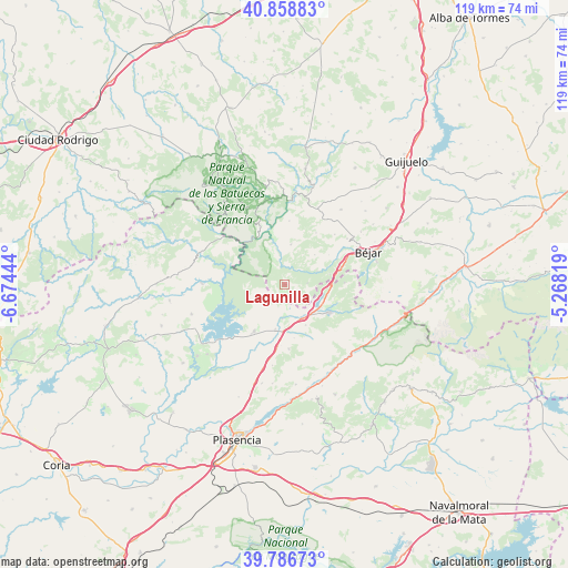
Lagunilla GPS coordinates[2]
40° 19' 29.676" North, 5° 58' 16.752" West
| Map corner | latitude | longitude |
|---|---|---|
| Upper-left | 40.85883°, | -6.67444° |
| Center: | 40.32491°, | -5.97132° |
| Lower-right: | 39.78673°, | -5.26819° |
| Map W x H: | 119.2×119.2 km | = 74.1×74.1mi |
| max Lat: | 43.74134° ⇑65.4% North |
| Lagunilla: | 40.32491° |
| min Lat: | ⇓34.6% South 27.64134° |
| min Long | Lagunilla | max Long |
| -18.00367° | -5.97132° | 4.2899° |
| W 14.4%⇐ | ⇒85.6% E |
Elevation
Elevation of Lagunilla is 925 m = 3035 ft, and this is 327 m = 1073 ft above average elevation for this country.
| Max E: |
1682 m = 5518 ft | 17.2% |
| Lagunilla | 925 m 3035 ft | |
| Avg. | 598 m = 1962 ft | |
Min E: |
0 m = 0 ft | 82.8% |
See also: Spain elevation on elevation.city.
Geographical zone
Lagunilla is located in North temperate zone (between Tropic of Cancer and the Arctic Circle). Distance of this Northern Tropic circle is 1877.8 km =1166.8 mi to South.| Distance of | km | miles | from Lagunilla |
|---|---|---|---|
| North Pole | 5523.4 | 3432.1 | to North |
| Arctic Circle | 2917.5 | 1812.8 | to North |
| Tropic Cancer | 1877.8 | 1166.8 | to South |
| Equator | 4483.7 | 2786 | to South |


Nearby cities:
15 places around Lagunilla: (largest is in red/bold)
• Abadía
7.3 km =4.5 mi,  184°
184°
• Aldeacipreste
8.8 km =5.5 mi,  45°
45°
• Aldeanueva del Camino
8.1 km =5 mi,  153°
153°
• Baños de Montemayor
9.5 km =5.9 mi,  95°
95°
• Colmenar de Montemayor
8.4 km =5.2 mi,  8°
8°
• El Cerro
4.7 km =2.9 mi, 101°
• Gargantilla
9.5 km =5.9 mi, 153°
• Hervás
10.7 km =6.6 mi,  124°
124°
• La Garganta
12.6 km =7.8 mi,  87°
87°
• Montemayor del Río
7 km =4.3 mi,  68°
68°
• Peñacaballera
9.6 km =6 mi,  77°
77°
• Puerto de Béjar
11.7 km =7.3 mi, 75°
• Segura de Toro
11.4 km =7.1 mi,  170°
170°
• Valdelageve
5.2 km =3.2 mi,  341°
341°
• Zarza de Granadilla
11.7 km =7.3 mi,  213°
213°
Sources, notices
• [Note1] Compared only with cities in Spain existing in our database
• [Src1] Map data: © OpenStreetMap contributors (CC-BY-SA)
• [Src2] Other city data from geonames.org with taken over terms of usage.
• [Src3] Geographical zone / Annual Mean Temperature by Robert A. Rohde @ Wikipedia
