La Garganta geodata
La Garganta (Extremadura) is a populated place; located in Spain in Europe/Madrid (GMT+2) time zone. With population of 562 people, there are 3711 cities with bigger population in this country. Compared to other cities in Spain, 65.2% of cities are located further ↑North; 83.5% of cities are located further →East and 94.8% of cities have lower elevation than La Garganta. Note1
Administrative division(s):
- Level 1: Extremadura
- Level 2: Provincia de Cáceres
- Level 3: Garganta, La


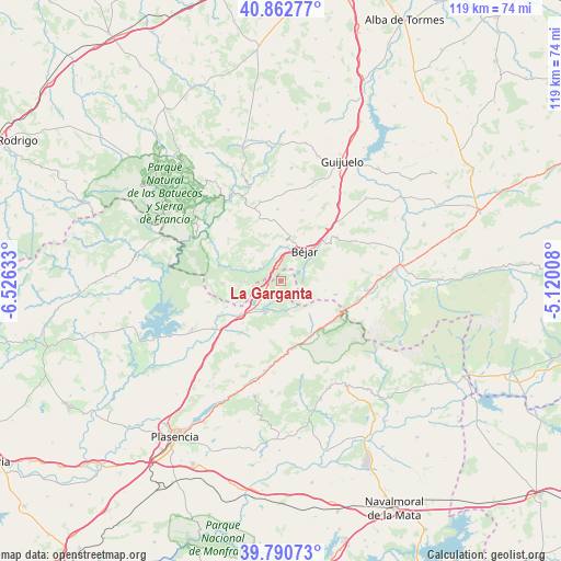
La Garganta GPS coordinates[2]
40° 19' 43.968" North, 5° 49' 23.556" West
| Map corner | latitude | longitude |
|---|---|---|
| Upper-left | 40.86277°, | -6.52633° |
| Center: | 40.32888°, | -5.82321° |
| Lower-right: | 39.79073°, | -5.12008° |
| Map W x H: | 119.2×119.2 km | = 74.1×74.1mi |
| max Lat: | 43.74134° ⇑65.2% North |
| La Garganta: | 40.32888° |
| min Lat: | ⇓34.8% South 27.64134° |
| min Long | La Garganta | max Long |
| -18.00367° | -5.82321° | 4.2899° |
| W 16.5%⇐ | ⇒83.5% E |
Elevation
Elevation of La Garganta is 1132 m = 3714 ft, and this is 534 m = 1752 ft above average elevation for this country.
| Max E: |
1682 m = 5518 ft | 5.2% |
| La Garganta | 1132 m 3714 ft | |
| Avg. | 598 m = 1962 ft | |
Min E: |
0 m = 0 ft | 94.8% |
See also: Spain elevation on elevation.city.
Geographical zone
La Garganta is located in North temperate zone (between Tropic of Cancer and the Arctic Circle). Distance of this Northern Tropic circle is 1878.2 km =1167.1 mi to South.| Distance of | km | miles | from La Garganta |
|---|---|---|---|
| North Pole | 5522.9 | 3431.8 | to North |
| Arctic Circle | 2917 | 1812.5 | to North |
| Tropic Cancer | 1878.2 | 1167.1 | to South |
| Equator | 4484.2 | 2786.4 | to South |


Nearby cities:
15 places around La Garganta: (largest is in red/bold)
• Aldeacipreste
8.6 km =5.3 mi,  312°
312°
• Aldeanueva del Camino
11.8 km =7.3 mi,  229°
229°
• Baños de Montemayor
3.4 km =2.1 mi,  246°
246°
• Béjar
8.2 km =5.1 mi,  38°
38°
• Candelario
7.9 km =4.9 mi,  56°
56°
• Cantagallo
4.9 km =3 mi,  4°
4°
• El Cerro
8 km =5 mi,  260°
260°
• Hervás
7.5 km =4.7 mi,  210°
210°
• Horcajo de Montemayor
12 km =7.5 mi,  330°
330°
• Montemayor del Río
6.4 km =4 mi,  289°
289°
• Navacarros
12 km =7.5 mi,  50°
50°
• Navalmoral de Béjar
11 km =6.8 mi,  18°
18°
• Peñacaballera
3.6 km =2.2 mi,  296°
296°
• Puerto de Béjar
2.7 km =1.7 mi, 333°
• Valdehijaderos
10.3 km =6.4 mi,  348°
348°
Sources, notices
• [Note1] Compared only with cities in Spain existing in our database
• [Src1] Map data: © OpenStreetMap contributors (CC-BY-SA)
• [Src2] Other city data from geonames.org with taken over terms of usage.
• [Src3] Geographical zone / Annual Mean Temperature by Robert A. Rohde @ Wikipedia
