A Coruña geodata
A Coruña (Galicia) is a seat of a third-order administrative division; located in Spain in Europe/Madrid (GMT+2) time zone. With population of 246,056 people, there are 19 cities with bigger population in this country. Compared to other cities in Spain, 98.5% of cities are located further ↓South; 97.1% of cities are located further →East and 95.6% of cities have higher elevation than A Coruña. Note1


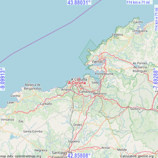
A Coruña GPS coordinates[2]
43° 22' 16.86" North, 8° 23' 45.6" West
| Map corner | latitude | longitude |
|---|---|---|
| Upper-left | 43.88031°, | -9.09913° |
| Center: | 43.37135°, | -8.396° |
| Lower-right: | 42.85808°, | -7.69288° |
| Map W x H: | 113.7×113.7 km | = 70.6×70.6mi |
| max Lat: | 43.74134° ⇑1.5% North |
| A Coruña: | 43.37135° |
| min Lat: | ⇓98.5% South 27.64134° |
| min Long | A Coruña | max Long |
| -18.00367° | -8.396° | 4.2899° |
| W 2.9%⇐ | ⇒97.1% E |
Elevation
Elevation of A Coruña is 22 m = 72 ft, and this is 576 m = 1890 ft below average elevation for this country.
| Max E: |
1682 m = 5518 ft | 95.6% |
| Avg. | 598 m = 1962 ft | |
| A Coruña | 22 m = 72 ft | |
Min E: |
0 m = 0 ft | 4.4% |
See also: A Coruña elevation on elevation.city.
Geographical zone
A Coruña is located in North temperate zone (between Tropic of Cancer and the Arctic Circle). Distance of this Northern Tropic circle is 2216.5 km =1377.3 mi to South.| Distance of | km | miles | from A Coruña |
|---|---|---|---|
| North Pole | 5184.6 | 3221.6 | to North |
| Arctic Circle | 2578.7 | 1602.3 | to North |
| Tropic Cancer | 2216.5 | 1377.3 | to South |
| Equator | 4822.4 | 2996.5 | to South |


Nearby cities:
15 places around A Coruña: (largest is in red/bold)
• Abegondo
19.5 km =12.1 mi,  152°
152°
• Ares
14 km =8.7 mi,  62°
62°
• Arteixo
11.7 km =7.3 mi,  230°
230°
• Bergondo
14.5 km =9 mi,  114°
114°
• Betanzos
17.8 km =11.1 mi,  124°
124°
• Cambre
9.4 km =5.8 mi,  155°
155°
• Carral
16.2 km =10.1 mi,  168°
168°
• Culleredo
9.3 km =5.8 mi,  176°
176°
• Ferrol
19.4 km =12.1 mi,  47°
47°
• Franza
16.9 km =10.5 mi, 58°
• Miño
16 km =9.9 mi,  98°
98°
• Mugardos
15.1 km =9.4 mi, 48°
• Oleiros
7.7 km =4.8 mi, 123°
• Pastoriza
7.1 km =4.4 mi, 233°
• Sada
11.3 km =7 mi, 98°
In other languages:
- In Spanish: La Coruña
- In France: La Corogne
- In Russian: Ла-Корунья
- In Chinese: 拉科魯尼亞
Sources, notices
• [Note1] Compared only with cities in Spain existing in our database
• [Src1] Map data: © OpenStreetMap contributors (CC-BY-SA)
• [Src2] Other city data from geonames.org with taken over terms of usage.
• [Src3] Geographical zone / Annual Mean Temperature by Robert A. Rohde @ Wikipedia
