Mugardos geodata
Mugardos (Galicia) is a seat of a third-order administrative division; located in Spain in Europe/Madrid (GMT+2) time zone. With population of 5,514 people, there are 1211 cities with bigger population in this country. Compared to other cities in Spain, 99.3% of cities are located further ↓South; 96.9% of cities are located further →East and 94.5% of cities have higher elevation than Mugardos. Note1


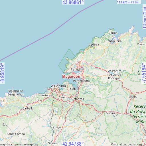
Mugardos GPS coordinates[2]
43° 27' 37.44" North, 8° 15' 18.252" West
| Map corner | latitude | longitude |
|---|---|---|
| Upper-left | 43.96861°, | -8.95819° |
| Center: | 43.4604°, | -8.25507° |
| Lower-right: | 42.94788°, | -7.55194° |
| Map W x H: | 113.5×113.5 km | = 70.5×70.5mi |
| max Lat: | 43.74134° ⇑0.7% North |
| Mugardos: | 43.4604° |
| min Lat: | ⇓99.3% South 27.64134° |
| min Long | Mugardos | max Long |
| -18.00367° | -8.25507° | 4.2899° |
| W 3.1%⇐ | ⇒96.9% E |
Elevation
Elevation of Mugardos is 27 m = 89 ft, and this is 571 m = 1873 ft below average elevation for this country.
| Max E: |
1682 m = 5518 ft | 94.5% |
| Avg. | 598 m = 1962 ft | |
| Mugardos | 27 m = 89 ft | |
Min E: |
0 m = 0 ft | 5.5% |
See also: Spain elevation on elevation.city.
Geographical zone
Mugardos is located in North temperate zone (between Tropic of Cancer and the Arctic Circle). Distance of this Northern Tropic circle is 2226.4 km =1383.4 mi to South.| Distance of | km | miles | from Mugardos |
|---|---|---|---|
| North Pole | 5174.7 | 3215.4 | to North |
| Arctic Circle | 2568.8 | 1596.2 | to North |
| Tropic Cancer | 2226.4 | 1383.4 | to South |
| Equator | 4832.3 | 3002.7 | to South |


Nearby cities:
15 places around Mugardos: (largest is in red/bold)
• A Coruña
15.1 km =9.4 mi,  228°
228°
• Ares
3.5 km =2.2 mi,  163°
163°
• Bergondo
16.1 km =10 mi,  173°
173°
• Betanzos
20.3 km =12.6 mi, 170°
• Cambre
19.9 km =12.4 mi,  202°
202°
• Fene
8.6 km =5.3 mi,  97°
97°
• Ferrol
4.3 km =2.7 mi,  41°
41°
• Franza
3.3 km =2.1 mi,  110°
110°
• Miño
13.1 km =8.1 mi, 160°
• Narón
6.9 km =4.3 mi,  48°
48°
• Oleiros
15 km =9.3 mi, 199°
• Paderne
20.5 km =12.7 mi, 161°
• Sada
11.6 km =7.2 mi,  181°
181°
• San Sadurniño
17.2 km =10.7 mi,  61°
61°
• Valdoviño
18.4 km =11.4 mi,  32°
32°
Sources, notices
• [Note1] Compared only with cities in Spain existing in our database
• [Src1] Map data: © OpenStreetMap contributors (CC-BY-SA)
• [Src2] Other city data from geonames.org with taken over terms of usage.
• [Src3] Geographical zone / Annual Mean Temperature by Robert A. Rohde @ Wikipedia
