Arteixo geodata
Arteixo (Galicia) is a seat of a third-order administrative division; located in Spain in Europe/Madrid (GMT+2) time zone. With population of 29,762 people, there are 308 cities with bigger population in this country. Compared to other cities in Spain, 97.6% of cities are located further ↓South; 97.3% of cities are located further →East and 95.1% of cities have higher elevation than Arteixo. Note1


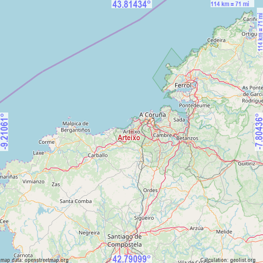
Arteixo GPS coordinates[2]
43° 18' 17.352" North, 8° 30' 26.964" West
| Map corner | latitude | longitude |
|---|---|---|
| Upper-left | 43.81434°, | -9.21061° |
| Center: | 43.30482°, | -8.50749° |
| Lower-right: | 42.79099°, | -7.80436° |
| Map W x H: | 113.8×113.8 km | = 70.7×70.7mi |
| max Lat: | 43.74134° ⇑2.4% North |
| Arteixo: | 43.30482° |
| min Lat: | ⇓97.6% South 27.64134° |
| min Long | Arteixo | max Long |
| -18.00367° | -8.50749° | 4.2899° |
| W 2.7%⇐ | ⇒97.3% E |
Elevation
Elevation of Arteixo is 24 m = 79 ft, and this is 574 m = 1883 ft below average elevation for this country.
| Max E: |
1682 m = 5518 ft | 95.1% |
| Avg. | 598 m = 1962 ft | |
| Arteixo | 24 m = 79 ft | |
Min E: |
0 m = 0 ft | 4.9% |
See also: Spain elevation on elevation.city.
Geographical zone
Arteixo is located in North temperate zone (between Tropic of Cancer and the Arctic Circle). Distance of this Northern Tropic circle is 2209.1 km =1372.7 mi to South.| Distance of | km | miles | from Arteixo |
|---|---|---|---|
| North Pole | 5192 | 3226.2 | to North |
| Arctic Circle | 2586.1 | 1606.9 | to North |
| Tropic Cancer | 2209.1 | 1372.7 | to South |
| Equator | 4815 | 2991.9 | to South |


Nearby cities:
15 places around Arteixo: (largest is in red/bold)
• A Coruña
11.7 km =7.3 mi,  50°
50°
• Abegondo
20.6 km =12.8 mi,  118°
118°
• Bergondo
22.2 km =13.8 mi,  86°
86°
• Betanzos
23.9 km =14.9 mi,  96°
96°
• Cambre
13 km =8.1 mi, 95°
• Carballo
18 km =11.2 mi,  235°
235°
• Carral
14.9 km =9.3 mi, 124°
• Cerceda
13.6 km =8.5 mi,  171°
171°
• Coristanco
22.8 km =14.2 mi, 239°
• Culleredo
9.8 km =6.1 mi, 101°
• Laracha
8.5 km =5.3 mi,  227°
227°
• Oleiros
15.8 km =9.8 mi,  78°
78°
• Pastoriza
4.6 km =2.9 mi, 46°
• Sada
21 km =13 mi,  74°
74°
• San Roque
22.8 km =14.2 mi, 239°
Sources, notices
• [Note1] Compared only with cities in Spain existing in our database
• [Src1] Map data: © OpenStreetMap contributors (CC-BY-SA)
• [Src2] Other city data from geonames.org with taken over terms of usage.
• [Src3] Geographical zone / Annual Mean Temperature by Robert A. Rohde @ Wikipedia
