Ares geodata
Ares (Galicia) is a seat of a third-order administrative division; located in Spain in Europe/Madrid (GMT+2) time zone. With population of 5,342 people, there are 1242 cities with bigger population in this country. Compared to other cities in Spain, 99.1% of cities are located further ↓South; 96.9% of cities are located further →East and 99.5% of cities have higher elevation than Ares. Note1


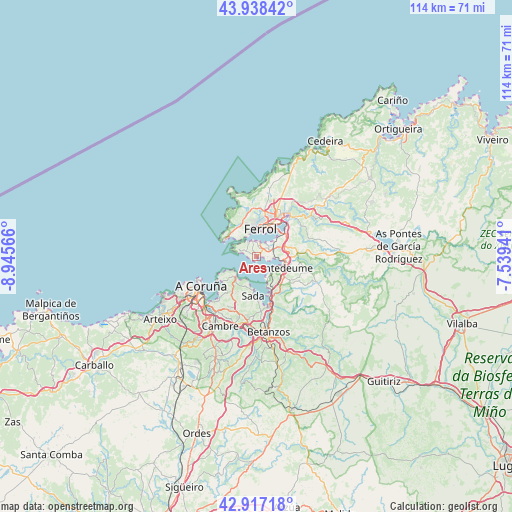
Ares GPS coordinates[2]
43° 25' 47.82" North, 8° 14' 33.144" West
| Map corner | latitude | longitude |
|---|---|---|
| Upper-left | 43.93842°, | -8.94566° |
| Center: | 43.42995°, | -8.24254° |
| Lower-right: | 42.91718°, | -7.53941° |
| Map W x H: | 113.6×113.5 km | = 70.6×70.5mi |
| max Lat: | 43.74134° ⇑0.9% North |
| Ares: | 43.42995° |
| min Lat: | ⇓99.1% South 27.64134° |
| min Long | Ares | max Long |
| -18.00367° | -8.24254° | 4.2899° |
| W 3.1%⇐ | ⇒96.9% E |
Elevation
Elevation of Ares is 6 m = 20 ft, and this is 592 m = 1942 ft below average elevation for this country.
| Max E: |
1682 m = 5518 ft | 99.5% |
| Avg. | 598 m = 1962 ft | |
| Ares | 6 m = 20 ft | |
Min E: |
0 m = 0 ft | 0.5% |
See also: Spain elevation on elevation.city.
Geographical zone
Ares is located in North temperate zone (between Tropic of Cancer and the Arctic Circle). Distance of this Northern Tropic circle is 2223 km =1381.3 mi to South.| Distance of | km | miles | from Ares |
|---|---|---|---|
| North Pole | 5178.1 | 3217.5 | to North |
| Arctic Circle | 2572.2 | 1598.3 | to North |
| Tropic Cancer | 2223 | 1381.3 | to South |
| Equator | 4829 | 3000.6 | to South |


Nearby cities:
15 places around Ares: (largest is in red/bold)
• A Coruña
14 km =8.7 mi,  242°
242°
• Bergondo
12.6 km =7.8 mi,  176°
176°
• Betanzos
16.8 km =10.4 mi,  172°
172°
• Cambre
17.3 km =10.7 mi,  209°
209°
• Culleredo
19.7 km =12.2 mi,  216°
216°
• Fene
7.8 km =4.8 mi,  73°
73°
• Ferrol
6.9 km =4.3 mi,  15°
15°
• Franza
3.1 km =1.9 mi,  43°
43°
• Miño
9.5 km =5.9 mi,  158°
158°
• Mugardos
3.5 km =2.2 mi,  343°
343°
• Narón
9 km =5.6 mi,  27°
27°
• Oleiros
12.3 km =7.6 mi, 209°
• Paderne
17 km =10.6 mi, 160°
• Sada
8.3 km =5.2 mi,  188°
188°
• San Sadurniño
18.3 km =11.4 mi,  50°
50°
Sources, notices
• [Note1] Compared only with cities in Spain existing in our database
• [Src1] Map data: © OpenStreetMap contributors (CC-BY-SA)
• [Src2] Other city data from geonames.org with taken over terms of usage.
• [Src3] Geographical zone / Annual Mean Temperature by Robert A. Rohde @ Wikipedia
