Iscar geodata
Iscar (Castille and León) is a populated place; located in Spain in Europe/Madrid (GMT+2) time zone. With population of 6,567 people, there are 1080 cities with bigger population in this country. Compared to other cities in Spain, 56.5% of cities are located further ↓South; 66.6% of cities are located further →East and 61.6% of cities have lower elevation than Iscar. Note1
Administrative division(s):
- Level 1: Castille and León
- Level 2: Provincia de Valladolid
- Level 3: Íscar


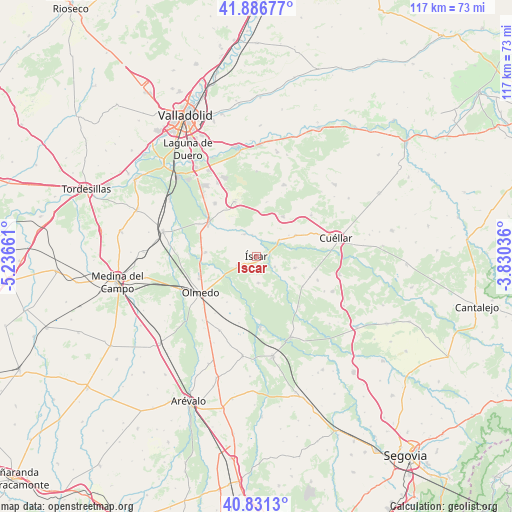
Iscar GPS coordinates[2]
41° 21' 40.212" North, 4° 32' 0.528" West
| Map corner | latitude | longitude |
|---|---|---|
| Upper-left | 41.88677°, | -5.23661° |
| Center: | 41.36117°, | -4.53348° |
| Lower-right: | 40.8313°, | -3.83036° |
| Map W x H: | 117.4×117.4 km | = 72.9×72.9mi |
| max Lat: | 43.74134° ⇑43.5% North |
| Iscar: | 41.36117° |
| min Lat: | ⇓56.5% South 27.64134° |
| min Long | Iscar | max Long |
| -18.00367° | -4.53348° | 4.2899° |
| W 33.4%⇐ | ⇒66.6% E |
Elevation
Elevation of Iscar is 755 m = 2477 ft, and this is 157 m = 515 ft above average elevation for this country.
| Max E: |
1682 m = 5518 ft | 38.4% |
| Iscar | 755 m 2477 ft | |
| Avg. | 598 m = 1962 ft | |
Min E: |
0 m = 0 ft | 61.6% |
See also: Spain elevation on elevation.city.
Geographical zone
Iscar is located in North temperate zone (between Tropic of Cancer and the Arctic Circle). Distance of this Northern Tropic circle is 1993 km =1238.4 mi to South.| Distance of | km | miles | from Iscar |
|---|---|---|---|
| North Pole | 5408.1 | 3360.4 | to North |
| Arctic Circle | 2802.2 | 1741.2 | to North |
| Tropic Cancer | 1993 | 1238.4 | to South |
| Equator | 4598.9 | 2857.6 | to South |


Nearby cities:
15 places around Iscar: (largest is in red/bold)
• Alcazarén
11.7 km =7.3 mi,  275°
275°
• Aldea de San Miguel
13 km =8.1 mi,  328°
328°
• Camporredondo
12.7 km =7.9 mi,  10°
10°
• Chañe
9.2 km =5.7 mi,  106°
106°
• Fresneda de Cuéllar
8.4 km =5.2 mi,  123°
123°
• Llano de Olmedo
12.4 km =7.7 mi,  212°
212°
• Mata de Cuéllar
6.5 km =4 mi,  52°
52°
• Megeces
5.7 km =3.5 mi,  335°
335°
• Pedrajas de San Esteban
4.6 km =2.9 mi,  241°
241°
• Remondo
4.7 km =2.9 mi, 118°
• San Cristóbal de Cuéllar
11.9 km =7.4 mi,  65°
65°
• San Miguel del Arroyo
11 km =6.8 mi,  33°
33°
• Vallelado
10.1 km =6.3 mi,  61°
61°
• Villaverde de Iscar
6.1 km =3.8 mi,  175°
175°
• Villeguillo
12.6 km =7.8 mi,  197°
197°
Sources, notices
• [Note1] Compared only with cities in Spain existing in our database
• [Src1] Map data: © OpenStreetMap contributors (CC-BY-SA)
• [Src2] Other city data from geonames.org with taken over terms of usage.
• [Src3] Geographical zone / Annual Mean Temperature by Robert A. Rohde @ Wikipedia
