Alcazarén geodata
Alcazarén (Castille and León) is a seat of a third-order administrative division; located in Spain in Europe/Madrid (GMT+2) time zone. With population of 711 people, there are 3386 cities with bigger population in this country. Compared to other cities in Spain, 56.8% of cities are located further ↓South; 68.3% of cities are located further →East and 59% of cities have lower elevation than Alcazarén. Note1
Administrative division(s):
- Level 1: Castille and León
- Level 2: Provincia de Valladolid
- Level 3: Alcazarén


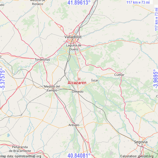
Alcazarén GPS coordinates[2]
41° 22' 14.196" North, 4° 40' 21.432" West
| Map corner | latitude | longitude |
|---|---|---|
| Upper-left | 41.89613°, | -5.37575° |
| Center: | 41.37061°, | -4.67262° |
| Lower-right: | 40.84081°, | -3.9695° |
| Map W x H: | 117.3×117.3 km | = 72.9×72.9mi |
| max Lat: | 43.74134° ⇑43.2% North |
| Alcazarén: | 41.37061° |
| min Lat: | ⇓56.8% South 27.64134° |
| min Long | Alcazarén | max Long |
| -18.00367° | -4.67262° | 4.2899° |
| W 31.7%⇐ | ⇒68.3% E |
Elevation
Elevation of Alcazarén is 737 m = 2418 ft, and this is 139 m = 456 ft above average elevation for this country.
| Max E: |
1682 m = 5518 ft | 41% |
| Alcazarén | 737 m 2418 ft | |
| Avg. | 598 m = 1962 ft | |
Min E: |
0 m = 0 ft | 59% |
See also: Spain elevation on elevation.city.
Geographical zone
Alcazarén is located in North temperate zone (between Tropic of Cancer and the Arctic Circle). Distance of this Northern Tropic circle is 1994.1 km =1239.1 mi to South.| Distance of | km | miles | from Alcazarén |
|---|---|---|---|
| North Pole | 5407.1 | 3359.8 | to North |
| Arctic Circle | 2801.2 | 1740.6 | to North |
| Tropic Cancer | 1994.1 | 1239.1 | to South |
| Equator | 4600 | 2858.3 | to South |


Nearby cities:
15 places around Alcazarén: (largest is in red/bold)
• Aguasal
10.8 km =6.7 mi,  171°
171°
• Aldea de San Miguel
11.1 km =6.9 mi,  25°
25°
• Iscar
11.7 km =7.3 mi,  95°
95°
• La Pedraja de Portillo
11.4 km =7.1 mi,  11°
11°
• Llano de Olmedo
12.5 km =7.8 mi,  156°
156°
• Matapozuelos
11 km =6.8 mi,  296°
296°
• Megeces
10.2 km =6.3 mi,  65°
65°
• Mojados
6.9 km =4.3 mi, 5°
• Olmedo
9.4 km =5.8 mi,  188°
188°
• Pedrajas de San Esteban
8.2 km =5.1 mi,  113°
113°
• Portillo
13.9 km =8.6 mi, 29°
• Pozal de Gallinas
15.1 km =9.4 mi,  247°
247°
• Valdestillas
14.4 km =8.9 mi,  325°
325°
• Ventosa de la Cuesta
13.8 km =8.6 mi,  289°
289°
• Villaverde de Iscar
14 km =8.7 mi,  120°
120°
Sources, notices
• [Note1] Compared only with cities in Spain existing in our database
• [Src1] Map data: © OpenStreetMap contributors (CC-BY-SA)
• [Src2] Other city data from geonames.org with taken over terms of usage.
• [Src3] Geographical zone / Annual Mean Temperature by Robert A. Rohde @ Wikipedia
