Megeces geodata
Megeces (Castille and León) is a seat of a third-order administrative division; located in Spain in Europe/Madrid (GMT+2) time zone. With population of 435 people, there are 4041 cities with bigger population in this country. Compared to other cities in Spain, 58% of cities are located further ↓South; 66.9% of cities are located further →East and 58.7% of cities have lower elevation than Megeces. Note1
Administrative division(s):
- Level 1: Castille and León
- Level 2: Provincia de Valladolid
- Level 3: Megeces


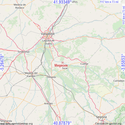
Megeces GPS coordinates[2]
41° 24' 29.808" North, 4° 33' 41.976" West
| Map corner | latitude | longitude |
|---|---|---|
| Upper-left | 41.93349°, | -5.26478° |
| Center: | 41.40828°, | -4.56166° |
| Lower-right: | 40.87879°, | -3.85853° |
| Map W x H: | 117.3×117.3 km | = 72.9×72.9mi |
| max Lat: | 43.74134° ⇑42% North |
| Megeces: | 41.40828° |
| min Lat: | ⇓58% South 27.64134° |
| min Long | Megeces | max Long |
| -18.00367° | -4.56166° | 4.2899° |
| W 33.1%⇐ | ⇒66.9% E |
Elevation
Elevation of Megeces is 735 m = 2411 ft, and this is 137 m = 449 ft above average elevation for this country.
| Max E: |
1682 m = 5518 ft | 41.3% |
| Megeces | 735 m 2411 ft | |
| Avg. | 598 m = 1962 ft | |
Min E: |
0 m = 0 ft | 58.7% |
See also: Spain elevation on elevation.city.
Geographical zone
Megeces is located in North temperate zone (between Tropic of Cancer and the Arctic Circle). Distance of this Northern Tropic circle is 1998.3 km =1241.7 mi to South.| Distance of | km | miles | from Megeces |
|---|---|---|---|
| North Pole | 5402.9 | 3357.2 | to North |
| Arctic Circle | 2797 | 1738 | to North |
| Tropic Cancer | 1998.3 | 1241.7 | to South |
| Equator | 4604.2 | 2860.9 | to South |


Nearby cities:
15 places around Megeces: (largest is in red/bold)
• Alcazarén
10.2 km =6.3 mi,  245°
245°
• Aldea de San Miguel
7.4 km =4.6 mi,  322°
322°
• Aldeamayor de San Martín
13.3 km =8.3 mi,  330°
330°
• Camporredondo
8.6 km =5.3 mi,  33°
33°
• Iscar
5.7 km =3.5 mi,  155°
155°
• La Pedraja de Portillo
9.9 km =6.2 mi,  314°
314°
• Mata de Cuéllar
7.6 km =4.7 mi,  99°
99°
• Mojados
9 km =5.6 mi,  287°
287°
• Pedrajas de San Esteban
7.6 km =4.7 mi,  193°
193°
• Portillo
8.2 km =5.1 mi,  343°
343°
• Remondo
9.9 km =6.2 mi,  139°
139°
• San Cristóbal de Cuéllar
13.1 km =8.1 mi,  91°
91°
• San Miguel del Arroyo
9.3 km =5.8 mi,  65°
65°
• Vallelado
11.3 km =7 mi, 92°
• Villaverde de Iscar
11.7 km =7.3 mi,  165°
165°
Sources, notices
• [Note1] Compared only with cities in Spain existing in our database
• [Src1] Map data: © OpenStreetMap contributors (CC-BY-SA)
• [Src2] Other city data from geonames.org with taken over terms of usage.
• [Src3] Geographical zone / Annual Mean Temperature by Robert A. Rohde @ Wikipedia
