Igriés geodata
Igriés (Aragon) is a seat of a third-order administrative division; located in Spain in Europe/Madrid (GMT+2) time zone. With population of 396 people, there are 4153 cities with bigger population in this country. Compared to other cities in Spain, 79.6% of cities are located further ↓South; 82.7% of cities are located further ←West and 54.3% of cities have higher elevation than Igriés. Note1


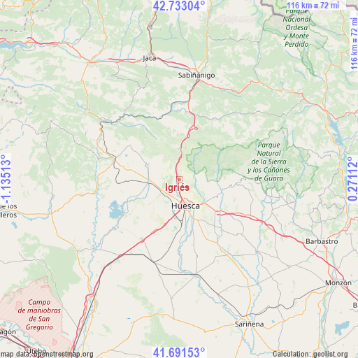
Igriés GPS coordinates[2]
42° 12' 51.948" North, 0° 25' 55.236" West
| Map corner | latitude | longitude |
|---|---|---|
| Upper-left | 42.73304°, | -1.13513° |
| Center: | 42.21443°, | -0.43201° |
| Lower-right: | 41.69153°, | 0.27112° |
| Map W x H: | 115.8×115.8 km | = 72×72mi |
| max Lat: | 43.74134° ⇑20.4% North |
| Igriés: | 42.21443° |
| min Lat: | ⇓79.6% South 27.64134° |
| min Long | Igriés | max Long |
| -18.00367° | -0.43201° | 4.2899° |
| W 82.7%⇐ | ⇒17.3% E |
Elevation
Elevation of Igriés is 607 m = 1991 ft, and this is 9 m = 30 ft above average elevation for this country.
| Max E: |
1682 m = 5518 ft | 54.3% |
| Igriés | 607 m 1991 ft | |
| Avg. | 598 m = 1962 ft | |
Min E: |
0 m = 0 ft | 45.7% |
See also: Spain elevation on elevation.city.
Geographical zone
Igriés is located in North temperate zone (between Tropic of Cancer and the Arctic Circle). Distance of this Northern Tropic circle is 2087.9 km =1297.4 mi to South.| Distance of | km | miles | from Igriés |
|---|---|---|---|
| North Pole | 5313.3 | 3301.5 | to North |
| Arctic Circle | 2707.4 | 1682.3 | to North |
| Tropic Cancer | 2087.9 | 1297.4 | to South |
| Equator | 4693.8 | 2916.6 | to South |


Nearby cities:
15 places around Igriés: (largest is in red/bold)
• Albero Alto
19.9 km =12.4 mi,  156°
156°
• Alcalá del Obispo
19.2 km =11.9 mi,  142°
142°
• Alerre
6.1 km =3.8 mi,  205°
205°
• Arguis
11.2 km =7 mi,  356°
356°
• Banastás
4.1 km =2.5 mi,  203°
203°
• Chimillas
5.2 km =3.2 mi, 198°
• Huesca
8.9 km =5.5 mi,  167°
167°
• Ibieca
19.4 km =12.1 mi,  107°
107°
• Loarre
19.4 km =12.1 mi,  304°
304°
• Loporzano
10.7 km =6.6 mi,  123°
123°
• Loscorrales
17.9 km =11.1 mi,  284°
284°
• Nueno
5.9 km =3.7 mi,  354°
354°
• Quicena
9.5 km =5.9 mi, 141°
• Siétamo
16 km =9.9 mi,  128°
128°
• Tierz
11 km =6.8 mi, 144°
Sources, notices
• [Note1] Compared only with cities in Spain existing in our database
• [Src1] Map data: © OpenStreetMap contributors (CC-BY-SA)
• [Src2] Other city data from geonames.org with taken over terms of usage.
• [Src3] Geographical zone / Annual Mean Temperature by Robert A. Rohde @ Wikipedia
